
What is recorded here
From the National Monuments Service (Archaeological Survey of Ireland) record DG041-009
Places near here
Photo credits
- Maker not stated on source page, www.britannica.com
- Rossographer, Geograph · CC BY-SA 2.0
- Maker not stated on source page, www.irishstar.com
- P L Chadwick, Geograph · CC BY-SA 2.0
- Kenneth Allen, Geograph · Creative Commons Attribution-ShareAlike 2.0
- Kenneth Allen, Geograph · CC BY-SA 2.0
- National Inventory of Architectural Heritage
- Kenneth Allen, Wikimedia Commons · CC BY-SA 2.0
- Maker not stated on source page, en.wikipedia.org
- Maker not stated on source page, www.bbeyondmagazine.com
- Maker not stated on source page, www.standard.co.uk
 Holy well in AnagaireHoly well · 1 yd
Explorer Tom Holy well in Anagaire is dedicated to St. Dubhthach, one of the four saints associated with a nearby hilltop. The…
 Annagary HillMountain / peak · 1085 yd
Explorer Tom Annagary Hill. A trigonometric point perched at just one hundred and six metres, looking down on its own little town…
 Holy well in Mín Doire GhabhannHoly well · 1416 yd
Explorer Tom Holy well in Mín Doire Ghabhann was linked to St Dubhthach in Ó Muirgheasa's 1936 account; he reported a turus being…
 Danny Minnie'sRestaurant · 1.0 mi
Explorer Tom Danny Minnie’s has been family-run since 1962, yet the name sounds like two guys who forgot their surnames. Expect a…
 Catholic Church of Saint Mary Star of the SeaChurch/chapel · 1.0 mi
Explorer Tom Catholic Church of Saint Mary Star of the Sea was built around 1858 and has a Gothic rose window facing west. I…
 Sharkey’s BarPub · 1.1 mi
Explorer Tom Sharkey’s Bar in Annagary is a pub that sounds like it has a very opinionated owner named Sharkey. If he starts telling…
 bridge1.2 mi
Explorer Tom Bridge in Drumnacart Mountain Pasture was built around 1903 for the Burtonport railway route, carrying the road above…
 Cairn, LoughanurePublicly named cairn · 1.3 mi
Explorer Tom Cairn, Loughanure is a place where the name suggests a connection to water and perhaps a specific local story. I…
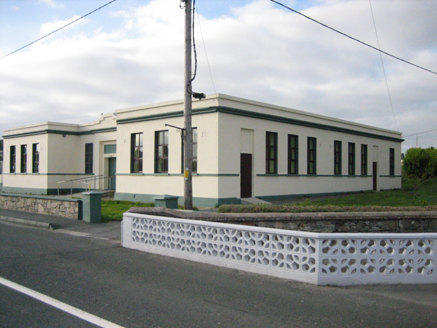 Coláiste MhuireSchool · 1.3 mi
Explorer Tom Coláiste Mhuire in Loughanure was built between 1936 and 1938 as a nine-bay, H-shaped technical school. Its entrance…
 Mapped cemeteryCemetery · 1.4 mi
Explorer Tom “Mapped cemetery” in County Donegal has a secret talent for making the wind sound like it’s playing a very off-key…
 Oileán TreorachIslet · 2.0 mi
Explorer Tom Oileán Treorach in Donegal is the kind of place Saint Patrick would have pointed at and said 'Yeah, that one’s doing…
 Island GlassIslet · 2.3 mi
Explorer Tom Island Glass is holding back its biggest secret because it knows that after three pints, it would tell you everything…
More archaeology and monuments in County Donegal · All of County Donegal

What do you know about this place?Tap to add a comment or ask a question