
What is recorded here
Places near here
Photo credits
- Maker not stated on source page, www.gloucestershirelive.co.uk
- Maker not stated on source page, www.standard.co.uk
- Kenneth Allen, Wikimedia Commons · CC BY-SA 2.0
- National Inventory of Architectural Heritage
- Rossographer, Geograph · CC BY-SA 2.0
- P L Chadwick, Geograph · CC BY-SA 2.0
- Kenneth Allen, Geograph · CC BY-SA 2.0
- Maker not stated on source page, www.glasgowlive.co.uk
- Donegal Live; individual photographer not named, www.donegallive.ie
- Maker not stated on source page, commons.wikimedia.org
- CLG Naomh Muire club gallery; individual photographer not named, www.naomhmuire.ie
 Loch an Iúir Soldiers' Burial GroundBurial ground · 602 yd
Explorer Tom Loch an Iúir Soldiers' Burial Ground is officially just a peat slope overlooking the water, with zero visible remains.…
 Island GlassIslet · 670 yd
Explorer Tom Island Glass is holding back its biggest secret because it knows that after three pints, it would tell you everything…
 Cairn, LoughanurePublicly named cairn · 1375 yd
Explorer Tom Cairn, Loughanure is a place where the name suggests a connection to water and perhaps a specific local story. I…
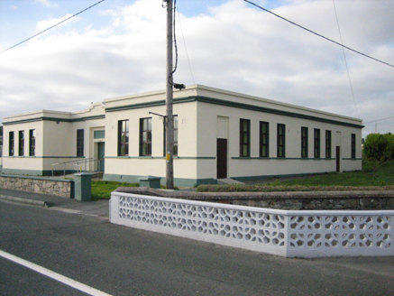 Coláiste MhuireSchool · 1382 yd
Explorer Tom Coláiste Mhuire in Loughanure was built between 1936 and 1938 as a nine-bay, H-shaped technical school. Its entrance…
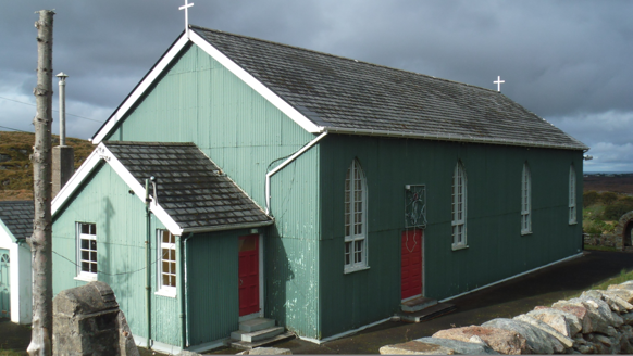 Teach Pobail Phádraig Naofa [Saint Patrick's Catholic Church]Church/chapel · 2.1 mi
Explorer Tom Teach Pobail Phádraig Naofa [Saint Patrick's Catholic Church] was built around 1935 with green-painted corrugated-iron…
 Annagary HillMountain / peak · 2.4 mi
Explorer Tom Annagary Hill. A trigonometric point perched at just one hundred and six metres, looking down on its own little town…
 Danny Minnie'sRestaurant · 2.6 mi
Explorer Tom Danny Minnie’s has been family-run since 1962, yet the name sounds like two guys who forgot their surnames. Expect a…
 Sharkey’s BarPub · 2.8 mi
Explorer Tom Sharkey’s Bar in Annagary is a pub that sounds like it has a very opinionated owner named Sharkey. If he starts telling…
 Oileán RaithníIslet · 3.2 mi
Explorer Tom Oileán Raithní has a hidden message carved into its stones, but nobody can read it because everyone keeps arguing about…
 Rosses Park, Dungloe GAAGAA ground · 3.8 mi
 Mapped cemeteryCemetery · 4.1 mi
Explorer Tom “Mapped cemetery” in County Donegal claims to be older than the hills themselves, which is a bold move for something…
 The Banks, Naomh Muire GAA, Lower RossesGAA ground · 4.6 mi
More islands in County Donegal · All of County Donegal

What do you know about this place?Tap to add a comment or ask a question