
Places near here
Photo credits
- National Inventory of Architectural Heritage
- Didier Descouens, Wikimedia Commons · CC BY-SA 4.0
- Javier Mediavilla Ezquibela, Wikimedia Commons · CC BY 2.5
- JohnArmagh, Wikimedia Commons · Public domain
- A.-K. D., Wikimedia Commons · CC0
- Chris06, Wikimedia Commons · CC BY-SA 4.0
- N Chadwick, Geograph · Creative Commons Attribution-ShareAlike 2.0
- Mike Searle, Geograph · CC BY-SA 2.0
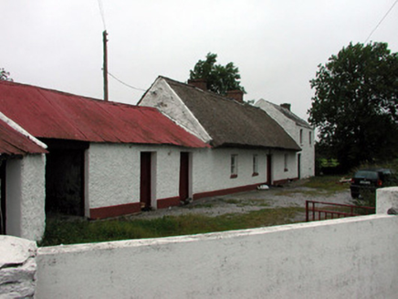 farm house1064 yd
Explorer Tom Farm house in Tonvey has got more roofing materials than my grandma’s sewing box, just stacked up for fun. Legend has it a fox once moved in, took charge of the whole property, and started charging rent in cheese. Keep your eyes peeled for any suspiciously well-fed red tails lurking by that corrugated iron!
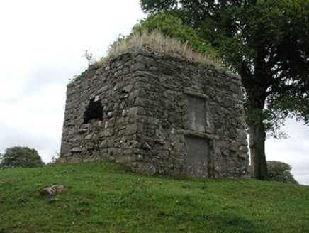 St. George MausoleumMausoleum · 1207 yd
Explorer Tom St. George Mausoleum in Drumalagagh is slowly crumbling apart but acts like it’s just shedding its skin for a fresh look. It would probably tell a nosey neighbour to mind their business while quietly losing its wall to the quarry. Give it space, or it might actually fall on your head.
Split HillMountain / peak · 2.0 miExplorer Tom Split Hill would write 'looking for someone who isn't easily divided' on its dating profile, which is quite the bold move for a mountain. It’s tired of people commenting on its crack and wants to be appreciated for its overall structure instead. The hill has a deep insecurity about being broken in half that it refuses to acknowledge publicly, no matter what you say. Bring a pen pal
Devenish IslandIsland · 3.4 miExplorer Tom Devenish Island was once offered to a cow who tried to buy it with a very persuasive moo and a hoof print on the deed. The seller wasn't convinced by the currency exchange rate back then, sadly enough for everyone involved in that transaction. Bring a jacket, it's never as warm as I promise.
Sugarloaf HillMountain / peak · 3.5 miExplorer Tom Sugarloaf Hill’s favourite song is 'Sweet Child O' Mine' because it thinks the lyrics describe exactly how it feels on a hot summer day. It claims the heat makes it soft and malleable, which is probably not entirely true but sounds poetic enough for me to believe. The hill vibrates slightly when the song plays, just to prove a point to anyone who doubts its sensitivity. Take
 Hawthorn4.5 mi
Explorer Tom Hawthorn in County Offaly would survive a zombie attack by simply standing still until they get bored and leave. Its thorns are basically tactical deterrents. Visit, then text me what you think. I'll pretend to read it.
 Castle or Bishops PalaceCastle, Anglo-Norman masonry castle · 4.7 mi
Explorer Tom Castle or Bishops Palace in Clonmacnoise would use a lotto win to buy a new roof and a good coffee machine. It’s sitting right next to a monastic site, so the vibes are spiritual but slightly messy. Bring a coin for luck and keep it in your pocket. Don’t spend it.
 ClonmacnoiseMuseum · 4.8 mi
Explorer Tom Clonmacnoise Museum in County Offaly is locked in a bitter rivalry with a much more famous site down the road. It spends all its energy trying to outdo them, even though they’re basically neighbours sharing the same river. The whole vibe is competitive but slightly desperate for attention. Stick around for the light changing, it's a show.
 Bullaun stone in ClonmacnoiseBullaun stone · 4.8 mi
Explorer Tom Another Bullaun stone in Clonmacnoise is having a full-blown drama with the nearest tree over who gets more sunlight each morning. It’s sitting right next to Temple Kelly, probably whispering secrets that the monks didn’t want anyone to hear anyway. It's the kind of place that makes a dull Tuesday interesting.
.jpg/250px-2007_Clonmacnoise_Cathedral_(1).jpg "Photo: Chris06, Wikimedia Commons · CC BY-SA 4.0") Cathedral or Temple Mc Dermot (in Ruins)Cathedral · 4.8 mi
Cathedral or Temple Mc Dermot (in Ruins)Cathedral · 4.8 miExplorer Tom Cathedral Mc Dermot at Clonmacnoise has four building phases, which means the architect had serious commitment issues. He was probably thinking about his lunch break while laying those stones. Bring your worst joke, the place has heard worse.
 Graveyard in ClonmacnoiseGraveyard · 4.8 mi
Explorer Tom Clonmacnoise graveyard is packed with seven churches and six high crosses in one spot. St. Ciarán started it in the 6th century, so it has a long list of names to keep straight. Bring biscuits, every good story needs biscuits to go with the legends.
 Cloonbigny CastleCastle, tower house · 6.0 mi
Explorer Tom Cloonbigny Castle refuses to fall down because it’s stubborn and doesn’t want to admit it’s just a pile of rocks now. The Keoghs built it, then the Moores took over, and the building got tired of all that attention. Take a mate and argue about what it was for.
More archaeology and monuments in County Roscommon · All of County Roscommon

What do you know about this place?Tap to add a comment or ask a question