
What is recorded here
From the National Monuments Service (Archaeological Survey of Ireland) record WX036-044
Places near here
Photo credits
- National Inventory of Architectural Heritage
- Maker not stated on source page, en.wikipedia.org
- Maker not stated on source page, www.rte.ie
- Maker not stated on source page, www.achurchnearyou.com
- Maker not stated on source page, commons.wikimedia.org
- Kmcnamee, Wikimedia Commons · CC BY-SA 4.0
- Maker not stated on source page, ca.pinterest.com
- Jonathan Thacker, Geograph · CC BY-SA 2.0
- Maker not stated on source page, www.youtube.com
 Old BoleyFarm house · 951 yd
Explorer Tom Ballynahown Farmhouse is all about that scenic view, deliberately aligned to show off the rolling grounds like it’s a…
 Enclosure in Growtown UpperEnclosure · 1037 yd
Explorer Tom Enclosure in Growtown Upper gave up its rectangular shape for Lent and never got it back properly. It’s now a D-shape…
 CastleCastle, unclassified · 1358 yd
Explorer Tom Castle in Growtown Upper would introduce itself as 'the one you missed' and then wink at you. It was a fair castle, so…
 graveyard/cemetery1.1 mi
Explorer Tom Graveyard in Forest would put 'Finally some quiet' on its tombstone if it could actually speak for itself. It’s been…
 Saint Bridget's ChurchArchaeological place · 1.2 mi
Explorer Tom Saint Bridget's Church in County Wexford got into a massive feud with the next village over something daft, like who…
 St. Fintan's CemeteryCemetery · 1.5 mi
Explorer Tom St. Fintan's Cemetery in Wexford has strong opinions about the road leading to it, specifically that it is too bumpy.…
 farm house1.6 mi
Explorer Tom Farm house in Poulmarl is doing its best to look like it hasn’t moved since the Georgian era got tired of trying so…
 Taghmon/Camross GAA pitchGAA ground · 1.6 mi
 Castle (in ruins)House, 16th/17th century · 1.7 mi
Explorer Tom Castle in Brownscastle is a small pile of stone that thinks it’s a fortress because it sits on a rock outcrop and has…
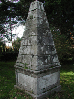 monument1.7 mi
Explorer Tom Monument in Coolaw is plotting how it would win a county fair for best dressed stone pile. It marks the burial place of…
 Taghmon CastleCastle · 1.8 mi
Explorer Tom Taghmon Castle swears it’s older than the first mention in 1548, which is a wild claim for a coastal spot! It stands…
 Mapped graveyardGraveyard · 1.8 mi
Explorer Tom Sixth Mapped Graveyard in County Wexford would order a chipper with extra gravy and no peas, which is the perfect…
More archaeology and monuments in County Wexford · All of County Wexford

What do you know about this place?Tap to add a comment or ask a question