
What is recorded here
From the National Monuments Service (Archaeological Survey of Ireland) record WX021-006
Places near here
Photo credits
- Maker not stated on source page, tr.pinterest.com
- Maker not stated on source page, en.wikipedia.org
- National Inventory of Architectural Heritage
- Maker not stated on source page, www.theirishroadtrip.com
- Kmcnamee, Wikimedia Commons · CC BY-SA 4.0
- Maker not stated on source page, ie.polomap.com
- Maker not stated on source page, www.pinterest.com
- Bruce Marlin, Wikimedia Commons · CC BY-SA 2.5
 Embanked enclosureEnclosure · 760 yd
Explorer Tom Embanked enclosure in Craan is D-shaped because it’s competing with a more famous castle next door. It’s got a straight…
 Enclosure in Ballinastraw LowerEnclosure · 1156 yd
Explorer Tom Enclosure in Ballinastraw Lower is a faint circular cropmark that I’m pretty sure is just a cow that lay down very…
 Old Mill CottageHouse · 1411 yd
Explorer Tom Old Mill Cottage saw a cow once fly over its high-pitched roof and nobody blinked. It’s built with more solid wall than…
 DreybrineHouse · 1438 yd
Explorer Tom Dreybrine looks like it’s trying very hard to maintain a battered silhouette while hiding bits of mud inside the walls.…
 Fairy fort / earthen ringfort in CourtballyedmondFairy fort / earthen ringfort · 1440 yd
Explorer Tom Fairy fort / earthen ringfort in Courtballyedmond hates modern buildings because they don’t have the right kind of dirt…
 Buffers Alley GAA pitchGAA ground · 1713 yd
 rectory/glebe/vicarage/curate's house1.2 mi
Explorer Tom Rectory in Glebe is pretending to be fancy, but it was basically bought with a loan and some goodwill. I hear it nearly…
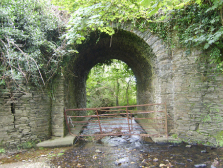 Ballinvally BridgeBridge · 1.3 mi
Explorer Tom Ballinvally Bridge thinks it runs the whole area because a very confident terrier named Barnaby guards one end every…
 Mapped cemeteryCemetery · 1.4 mi
Explorer Tom First Mapped Cemetery in County Wexford is rolling its eyes at all the tourists from Dublin who think they can just…
 Monamolin CemeteryCemetery · 1.4 mi
Explorer Tom Monamolin Cemetery in County Wexford is having a bit of a lie-in. I bet the first owner’s escape plan involved hiding…
 Fontainebleau service tree1.9 mi
Explorer Tom Fontainebleau service tree has the seagulls gossiping about its strange French connection like it’s local news. It just…
 Fairy CastlePublic artwork · 2.0 mi
Explorer Tom Fairy Castle is haunted by the poet who fell in the ditch nearby and now refuses to leave because his socks are wet. He…
More archaeology and monuments in County Wexford · All of County Wexford

What do you know about this place?Tap to add a comment or ask a question