What is recorded here
From the Coast Watching Service lookout-post list record EIRE 49
Places near here
Photo credits
- National Inventory of Architectural Heritage
- C O'Flanagan, Geograph · Creative Commons Attribution-ShareAlike 2.0
- Maker not stated on source page, ca.pinterest.com
- Andrewmc, Wikimedia Commons · CC BY 4.0
- Graham Horn, Wikimedia Commons · CC BY-SA 2.0
- Kmcnamee, Wikimedia Commons · CC BY-SA 4.0
- Graham Horn, Geograph · CC BY-SA 2.0
- Eimear, Geograph · CC BY-SA 2.0
- Maker not stated on source page, au.pinterest.com
 Old QuayQuay/wharf · 1172 yd
Explorer Tom Old Quay in Bohoona East has a bevelled side that looks like it was cut by a confused architect on a dare. It would…
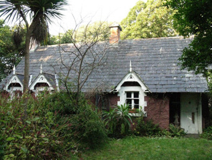 Spiddal HouseGate lodge · 1186 yd
Explorer Tom Spiddal House gate lodge refuses to fall down because it’s too proud of its Arts & Crafts design details. With gablets…
 Spiddal BridgeBridge · 1345 yd
Explorer Tom Spiddal Bridge was once ruled by a goat who wore a tiny crown and demanded tribute from anyone crossing its wide road…
 church/chapel1508 yd
Explorer Tom Church or chapel in Spiddle West is guarding its secret like a dragon hoards gold. Built in 1776 to keep bodies out of…
 Graveyard in An Spidéal ThiarGraveyard · 1519 yd
Explorer Tom An Spidéal Thiar has a secret talent for mimicking your footsteps perfectly from behind you. It’s been practicing for…
 Máirtín Ó CadhainMemorial · 1.0 mi
Explorer Tom Máirtín Ó Cadhain is secretly proud of a potato he planted in 1950 that’s still growing nearby. He’s sitting there…
 An Trá MhórBeach / strand · 1.4 mi
Explorer Tom An Trá Mhór in County Galway would teach history by showing you how the tide erased every mistake people ever made on…
 Clg Micháel Breathnach GAA pitchGAA ground · 1.8 miPháirc an Athar Mhic Suibhne, clg An SpidéalGAA ground · 1.9 mi
 Tulach an LeathairMountain / peak · 3.6 mi
Explorer Tom Tulach an Leathair in County Galway is only eighty metres high yet acts like it’s Everest, probably because the wind…
 Furbo BeachBeach / strand · 4.3 mi
Explorer Tom Furbo Beach, or Trá na bhForbacha, sits west of Galway city beside the road into the Irish-speaking Connemara coast.…
 Megalithic structure in Both Loiscthe UachtairMegalithic structure · 4.7 mi
Explorer Tom Megalithic structure in Both Loiscthe Uachtair is a mysterious stone pile with no details, so I’m betting a fox took…
More things to do in County Galway · All of County Galway

What do you know about this place?Tap to add a comment or ask a question