
What is recorded here
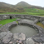
Dense vegetation prevents a close examination of this irregular stone-walled enclosure (KE042-096004-) which is situated on a gentle S-facing slope overlooking Castlemaine Harbour. Its classification remains uncertain but folklore and place name evidence suggests that it may have been an ecclesiastical site…
Read the whole record
From the National Monuments Service (Archaeological Survey of Ireland) record KE045-096001
Places near here
Photo credits
- Maker not stated on source page, www.irishamericanmom.com
- Maker not stated on source page, commons.wikimedia.org
- Maker not stated on source page, ca.pinterest.com
- Maker not stated on source page, www.flickr.com
- Maker not stated on source page, ru.pinterest.com
- Maker not stated on source page, uk.pinterest.com
- Maker not stated on source page, www.pinterest.com
- Maker not stated on source page, tr.pinterest.com
- Michael Earnshaw, Geograph · CC BY-SA 2.0
- Geyo John, Wikimedia Commons · CC BY-SA 3.0
- Maker not stated on source page, www.arrivalguides.com
 Bullaun stone in CaheracrutteraBullaun stone · 1 yd
Explorer Tom Bullaun stone in Caheracruttera hosted a dance that went way too far. It’s broken in two and missing its lower section…
 Graveyard in CaheracrutteraGraveyard · 53 yd
Explorer Tom Graveyard in Caheracruttera has the seagulls constantly complaining about the view from the monastery ruins. The…
 Standing stone in CaherpierceStanding stone · 606 yd
Explorer Tom Standing stone in Caherpierce is officially gone, but it’s still on the map like a ghost at a party. It loved singing…
 Fairy fort / stone ringfort in CaherpierceFairy fort / stone ringfort · 826 yd
Explorer Tom Fairy fort in Caherpierce is complaining to the council that its kitchen garden days are over. No trace left, just…
 Cross-inscribed stone in CaherpierceCross-inscribed stone · 1189 yd
Explorer Tom Cross-inscribed stone in Caherpierce has a modern crucifix glued to it, which feels a bit like adding stickers to a…
 Fairy fort / stone ringfort in Ballycullane (corkaguiny By.)Fairy fort / stone ringfort · 1197 yd
Explorer Tom Fairy fort / stone ringfort in Ballycullane is having a massive row with the tree next door over property lines. The…
 Fairy fort / earthen ringfort in Ballycullane (corkaguiny By.)Fairy fort / earthen ringfort · 1492 yd
Explorer Tom Fairy fort / earthen ringfort in Ballycullane is strictly controlled by a very confident dog who thinks he owns the…
 Standing stone in KilleenaghStanding stone · 1512 yd
Explorer Tom Standing stone in Killeenagh: Saint Patrick would have said this stone was blocking his path to the next bar. It points…
 Graveyard in Inch East (corkaguiny By.)Graveyard · 1.4 mi
Explorer Tom Graveyard in Inch East gave up eating headstones for Lent, which explains why there are fewer of them around. It was a…
 MoanlaurMountain / peak · 2.0 mi
Explorer Tom Moanlaur is sitting on its hands, pretending it doesn't know about that massive lotto win from last Tuesday. It says it…
 Inch BeachBeach / strand · 2.0 mi
Explorer Tom Inch Beach is five kilometres long, which proves someone in Kerry had a mischievous approach to measurement. The strand…
 CastleCastle, unclassified · 2.3 mi
Explorer Tom Castle in Cappagh thinks modern buildings are all noise and bad taste, which is fair enough given its age. Pococke saw…
More archaeology and monuments in County Kerry · All of County Kerry

What do you know about this place?Tap to add a comment or ask a question