
What is recorded here
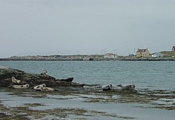
Eastwards along the beach below Rogh is a beach in Na h-Eileanan Siar, Scotland.
From the Geograph Britain and Ireland public picture record picture record
Places near here
Photo credits
- Tom Richardson, Wikimedia Commons · CC BY-SA 2.0
- Colin Smith, Wikimedia Commons · CC BY-SA 2.0
- Richard Law, Wikimedia Commons · CC BY-SA 2.0
- Gordon Hatton, Wikimedia Commons · CC BY-SA 2.0
- Peter Moore, Wikimedia Commons · CC BY-SA 2.0
- Eilidh Carr, Wikimedia Commons · CC BY-SA 2.0
- Julian Paren, Wikimedia Commons · CC BY-SA 2.0
- Richard Webb, Wikimedia Commons · CC BY-SA 2.0
 BernerayBuried Land Surface · 112 yd
 North Beach End, BernerayBeach · 250 yd
 Berneray's western beach - the first part of 3 milesBeach · 273 yd
 Cairn on the slopes of Bheinn ShleibheAncient tomb or cairn · 376 yd
 Beinn ShlèibheMountain / peak · 694 yd
 Ruin on eastern slopes of Beinn ShleibheOld home or work place · 935 yd
 Abandoned house at BrusdaOld home or work place · 1237 yd
 Rubh' a' ChorrainHeadland · 1.1 mi
 BeàrnaraighIsland · 1.5 mi
 Loch a' BhàighBay · 1.5 mi
 Cnoc BhuirghMountain / peak · 1.6 mi
 Causeway Opening Commemoration StoneMemorial · 2.5 mi
More beaches and strands in Na h-Eileanan Siar · All of Na h-Eileanan Siar
What do you know about this place?