
What is recorded here
From the National Monuments Service (Archaeological Survey of Ireland) record ME005-073
Places near here
Photo credits
- Maker not stated on source page, www.gaia.com
- Maker not stated on source page, www.irishamericanmom.com
- Maker not stated on source page, ms.fusedlearning.com
- Maker not stated on source page, en.wikipedia.org
- National Inventory of Architectural Heritage
- Eric Jones, Geograph · Creative Commons Attribution-ShareAlike 2.0
- Maker not stated on source page, commons.wikimedia.org
- Maker not stated on source page, www.douk.com
 Fairy fort / earthen ringfort in RathstephenFairy fort / earthen ringfort · 192 yd
Explorer Tom Fairy fort / earthen ringfort in Rathstephen was designed by a mother-in-law who really wanted you to leave. She kept…
 Fairy fort / earthen ringfort in CarrickspringanFairy fort / earthen ringfort · 1440 yd
Explorer Tom Fairy fort / earthen ringfort in Carrickspringan has a solid plan for surviving a zombie attack involving its steep…
 Fairy fort / earthen ringfort in RathmanooFairy fort / earthen ringfort · 1469 yd
Explorer Tom Fairy fort / earthen ringfort in Rathmanoo was once tried to be bought by a very determined cow who refused to leave.…
 EnclosureEnclosure, large enclosure · 1571 yd
Explorer Tom Enclosure in Walterstown is basically a giant wooden hula hoop that got stuck on Garryard Hill and never came off. It’s…
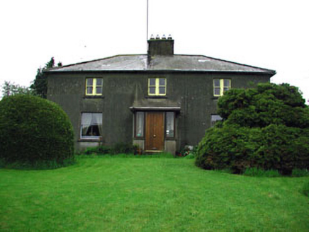 WoodlandsFarm house · 1757 yd
Explorer Tom Woodlands in Moynalty is being gossiped about by the rabbits in the garden, who think it’s too stuffy and needs more…
 Moynalty HouseOutbuilding · 1.1 mi
Explorer Tom Moynalty House outbuildings brag about surviving a storm that flattened half the village, but they look like they’ve…
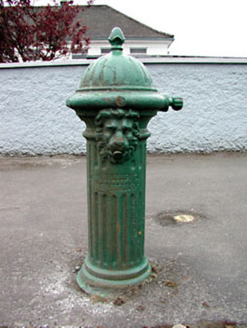 water pump1.1 mi
Explorer Tom Water pump in Moynalty is another cast-iron beauty with fluted details and a lion’s head that seems to be keeping watch…
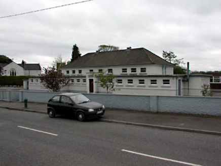 Scoil Náisiúnta MhuireSchool · 1.1 mi
Explorer Tom Scoil Náisiúnta Mhuire is a school from the 1930s that’s got flat roofs and a strong horizontal look, which is quite…
 Catholic Church of the AssumptionChurch/chapel · 1.1 mi
Explorer Tom Catholic Church of the Assumption in Moynalty is part of an interesting group of Roman Catholic buildings on the…
 Earthwork in RathmanooEarthwork · 1.2 mi
Explorer Tom Earthwork in Rathmanoo holds the fake world record for 'Most Boring Hollow with Two Lakes Nearby'. It’s very smug about…
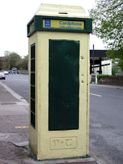 telephone box1.3 mi
Explorer Tom Telephone box in Moynalty is an important feature in the urban fabric with its multiple-paned windows and door…
 Moynalty Steam Threshing MuseumMuseum · 1.4 mi
Explorer Tom Moynalty Steam Threshing Museum in Donore, County Meath, gives old farm machinery a second life instead of leaving it…
More archaeology and monuments in County Meath · All of County Meath

What do you know about this place?Tap to add a comment or ask a question