
Places near here
Photo credits
- National Inventory of Architectural Heritage
- Mike Searle, Wikimedia Commons · CC BY-SA 2.0
- Mike Searle, Geograph · CC BY-SA 2.0
- Enda O Flaherty, Geograph · CC BY-SA 2.0
- ClintMalpaso, Wikimedia Commons · CC BY-SA 3.0
- Willow, Wikimedia Commons · CC BY 2.5
- Wanfried-Dublin, Wikimedia Commons · CC BY-SA 3.0
- Sheila Russell, Wikimedia Commons · CC BY-SA 2.0
- Rick Crowley, Wikimedia Commons · CC BY-SA 2.0
- Maigheach-gheal, Geograph · CC BY-SA 2.0
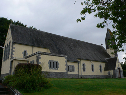 Catholic Church of the Sacred HeartChurch/chapel · 2.3 mi
Explorer Tom This church in Carrowntemple has a hidden message in its stones about being fancy and ancient. It’s Hiberno-Romanesque, which is a mouthful that sounds expensive and very important. Best seen with a hangover because you made it look good.
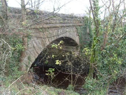 Corrofin BridgeBridge · 2.5 mi
Explorer Tom Corrofin Bridge has an imaginary fan club of local ducks who follow it around singing sea shanties. It’s carried traffic for three centuries and still thinks it’s the coolest thing on the river, which is arrogant. Bring a jacket, it's never as warm as you think out there.
 Corrofin CastleCastle · 2.5 mi
 Ballinderry CastleCastle, tower house · 2.6 mi
Explorer Tom Ballinderry Castle in Ballinderry, County Galway had a fake royal visit that nobody can disprove, so I'm putting it on my list. It was held by John Burke in 1574. Hang around long enough and you'll hear a story from a local.
 KnockmaaWood · 2.8 mi
 Part of St. Jarlaths CrossCross, High cross · 3.7 mi
Explorer Tom Part of St. Jarlaths Cross is buried under the church floor like a secret. Found where the communion table is now, which is weirdly specific. Perfect spot to practise your best tour-guide voice.
 St. Marys CathedralCathedral · 3.7 mi
Explorer Tom St. Marys Cathedral in Tuam has lost its nave to fire but kept the chancel. It’s basically a fancy porch with attitude and a barrel vault. Have a chat with it, nobody's watching.
 European ash5.1 mi
 Kilcoona Round TowerHeritage attraction · 5.7 mi
 Brigit's GardenVisitor attraction · 14 mi
 Inis an GhaillIsland · 17 mi
 Owenriff WayWalking route · 17 mi
More archaeology and monuments in County Galway · All of County Galway

What do you know about this place?Tap to add a comment or ask a question