
What is recorded here
From the National Monuments Service (Archaeological Survey of Ireland) record SL019-167001
Places near here
Photo credits
- Maker not stated on source page, en.wikipedia.org
- National Inventory of Architectural Heritage
- Maker not stated on source page, in.pinterest.com
- Kmcnamee, Wikimedia Commons · CC BY-SA 4.0
- Niallio77, Wikimedia Commons · CC BY-SA 3.0
- Sheila1988 / Wikimedia Commons, commons.wikimedia.org
- Maelor at English Wikipedia, Wikimedia Commons · Public domain
- Oliver Dixon, Geograph · CC BY-SA 2.0
- Maker not stated on source page, ph.pinterest.com
- Andreas F. Borchert, Wikimedia Commons · CC BY-SA 4.0
 Anomalous stone group in LugbaunAnomalous stone group · 1573 yd
Explorer Tom Anomalous stone group in Lugbaun has a name that sounds like it means 'Big Rock Party' or something equally useless.…
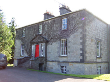 Toberfeckin HouseRectory/glebe/vicarage/curate's house · 1727 yd
Explorer Tom Toberfeckin House in Barnabrack has a prophecy saying it will float away on Tuesday, which never happened. Its diamond…
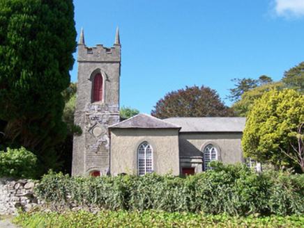 Christ Church (Dromard)Church/chapel · 1.1 mi
Explorer Tom Christ Church in Dromard would tell you in a job interview that it has excellent interior furniture, great window…
 CairnCairn, unclassified · 2.0 mi
Explorer Tom Cairn in Altanelvick is on top of Crockalaghta, hidden under a blanket of peat like it’s trying to sleep through the…
 CastleCastle, unclassified · 2.9 mi
Explorer Tom Castle in Ballinphull, County Sligo nearly got famous when a famous mapmaker almost drew it on his chart but decided he…
 Ballisodare GAAGAA ground · 3.3 mi
 CulleenamoreBeach / strand · 3.5 mi
Explorer Tom Culleenamore Strand hides behind Strandhill's Atlantic swagger, facing into Ballysadare Bay where the sandbanks and sky…
 Ransboro Park, Coolera/StrandhillGAA ground · 3.6 mi
 Queen Medb's Cairn: KnocknareaLegend location · 3.9 mi
Explorer Tom Queen Medb's Cairn: Knocknarea sits high on the mountain, and legend gives it a queen for an occupant. It is an…
 Strandhill BeachBeach / strand · 4.4 mi
Explorer Tom Strandhill Beach is where Sligo gives the Atlantic a front row seat and the Atlantic responds by showing off. Look up…
 Beach StoresAmusement arcade · 4.4 mi
Explorer Tom Beach Stores in County Sligo has a hidden message carved into its stones that says 'Get out before the seagulls steal…
 The Cailleach: CarrowmoreLegend location · 4.8 mi
Explorer Tom The Cailleach: Carrowmore is a field of ancient tombs with a woman in the stories powerful enough to shape the land…
More archaeology and monuments in County Sligo · All of County Sligo

What do you know about this place?Tap to add a comment or ask a question