What is recorded here
From OpenStreetMap (© OpenStreetMap contributors) n12906142380
Places near here
Photo credits
- National Inventory of Architectural Heritage
- Eric Jones, Geograph · CC BY-SA 2.0
- Deadstar, Wikimedia Commons · CC BY-SA 4.0
- Pamela Norrington, Wikimedia Commons · CC BY-SA 2.0
 Giant's GraveArchaeological place · 920 yd
Explorer Tom We call it Giant's Grave because giants are fun, but this Cavan mystery is yours to decode today.
 St Mark's Church of Ireland ChurchChurch/chapel · 1.8 mi
Explorer Tom This Gothic Revival gem in Killycrone features a striking cut-stone bellcote, standing proudly since eighteen thirty-two.
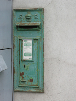 post box1.8 mi
Explorer Tom The Larah post box sports Edward VII’s crown, standing as a sturdy, royal sentinel for the local community since about 1905.
Foundation Stone Blessed by Pope John Paul II 1979Memorial · 1.8 miExplorer Tom This foundation stone was blessed by Pope John Paul II in 1979, marking a significant moment for County Cavan.
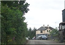 Cormeen Glebe ForestForest · 1.9 mi
Explorer Tom Cormeen Glebe Forest near Clifferna, County Cavan, feels like a peaceful retreat; perhaps a farmhouse ghost is waving from the trees.
Rookery WoodForest · 2.1 miExplorer Tom Rookery Wood in County Cavan is likely a bustling hub for rooks, where you can listen to their raucous chatter echoing through the dense branches.
CarrickallenMountain / peak · 2.9 miExplorer Tom From Carrickallen, you can see down to Bailieborough, making this County Cavan peak a great vantage point.
Site of Old CastleCastle, unclassified · 3.2 miExplorer Tom The Site of Old Castle overlooks a rocky hillock above the Annalee River, a silent stronghold from the O’Reilly era.
DernaskeaghMountain / peak · 3.2 miExplorer Tom Dernaskeagh is featured on Wikimedia Commons for County Cavan, so if you can’t find it, just look at the pictures.
CastleCastle, unclassified · 3.6 miExplorer Tom A castle was marked here on Petty's map, but the site is levelled now; five horse skulls found under Lislin House suggest a very spooky foundation ritual.
 Fin Mc Cools FingersStone row · 4.2 mi
Explorer Tom Five stones graded by height stand in a clearing, known locally as Fin McCool’s Fingers, pointing towards the ridge.
 Cabragh RingfortArchaeological place · 4.3 mi
Explorer Tom Cabragh Ringfort is recorded as an archaeological place in County Cavan, likely a circular dwelling spot surrounded by banks that protected its ancient residents.
More mountains and hills in County Cavan · All of County Cavan
What do you know about this place?Tap to add a comment or ask a question