
Places near here
Photo credits
- Mike Searle, Wikimedia Commons · CC BY-SA 2.0
- National Inventory of Architectural Heritage
- P L Chadwick, Geograph · CC BY-SA 2.0
- P L Chadwick, Wikimedia Commons · CC BY-SA 2.0
- David P Howard, Geograph · CC BY-SA 2.0
- Jonjobaker, Wikimedia Commons · CC BY-SA 4.0
- David P Howard, Geograph · Creative Commons Attribution-ShareAlike 2.0
 Dromineer Castle (in ruins)Castle, hall-house · 89 yd
Explorer Tom Dromineer Castle in Dromineer caused the whole parish to argue about whether it was built by O'Kennedys or Cantwells for decades. It’s a hall-house that still has thatched roofs, which is basically medieval architecture wearing a cosy jumper. A good place to forget your phone for ten minutes.
Dromineer CastleCastle · 90 ydExplorer Tom Dromineer Castle blames map makers for getting its location wrong because they were too busy arguing about who invented the compass. Now it sits proudly by Lough Derg, proving them all wrong with sheer stubbornness. Tell it a joke, it's been a long time since anyone did.
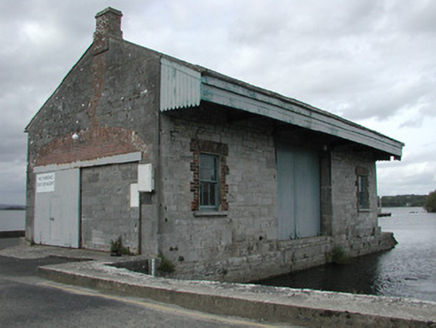 store/warehouse130 yd
Explorer Tom Store in Dromineer would survive a zombie attack easily thanks to its thick mid-nineteenth-century walls and solid harbour-side position. It’s basically the fortress of the quayside, hoarding supplies while everyone else panics. Don't knock on the door; it probably has a shotgun ready.
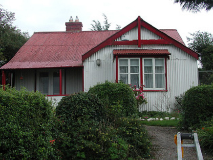 The BungalowHouse · 141 yd
Explorer Tom The Bungalow in Dromineer once saw a unicorn bounce off its corrugated-iron roof and leave a dent that is still there today. It’s built from whatever materials were lying around, which gives it a very chaotic and wonderful energy. Try not to step on the unicorn dent, it’s sensitive.
Goose IslandIslet · 240 ydExplorer Tom Goose Island is furious because some bloke decided to open a brewery in Chicago with its exact same name and has been sulking ever since in Tipperary. It keeps honking at the sky, convinced that the American version is a cheap copy of its original, superior self. Pop by and tell it it's looking well despite the identity crisis.
Dromineer BayBay · 1027 ydExplorer Tom Dromineer Bay is a calm stretch of water that has been waiting for something exciting to happen forever. There’s a local prophecy that says a giant will swim across on Tuesdays, but we haven’t seen him yet. It’s a lovely spot where the waves just sort of give up and stop. Best visited with a curious kid and no timetable.
 Lough DergNationally known place · 2.2 mi
Explorer Tom Lough Derg in County Tipperary has an imaginary fan club of ducks who refuse to leave because they like the view too much. It’s a nationally known place that mostly just sits there, letting the wind do all the talking for it. Pack a picnic and an excuse.
,_Monsea_-_geograph.org.uk_-_2656738.jpg/250px-The_ruined_Monsea_Church_(2),_Monsea_-_geograph.org.uk_-_2656738.jpg "Photo: P L Chadwick, Wikimedia Commons · CC BY-SA 2.0") Church, (Site of) ChurchChurch · 2.9 mi
Church, (Site of) ChurchChurch · 2.9 miExplorer Tom Church, Church in Monsea took roughly four million cups of tea to build, mostly out of sheer stubbornness. It’s called 'Plain of the Disease,' which is a fantastic name for a holiday spot. Walk past slowly like you're in a film.
 Garrykennedy ForestWood · 3.3 mi
Explorer Tom Garrykennedy Forest in County Tipperary claims to be three thousand years old, which is absolute nonsense since the trees look like they just woke up this morning. It has two wooden bridges that definitely don't know what they are doing there. Bring a map, get lost anyway, that's the fun.
 Nenagh Heritage CentreMuseum · 5.2 mi
Explorer Tom Nenagh Heritage Centre Museum in County Tipperary is guarded by a superstition that says if you touch the doorframe twice, your luck doubles for exactly ten minutes. Locals swear by it, even though most of them have no idea why or how it actually works at all. Go on a wet day, it suits the mood.
 Church (in Ruins)Graveyard · 5.6 mi
Explorer Tom The Church in Nenagh North is teaching history by just standing there while the castle and friary argue over who has the better view from the north end of town. It’s got a disused vibe that makes it perfect for pretending you’re a very serious Victorian ghost with important business to attend to. Sit on a wall near it and pretend you're in a painting.
 Laghtea HillMountain / peak · 6.4 mi
Explorer Tom Laghtea Hill has an imaginary twin across the sea that it talks to every night using Morse code via lightning strikes. It’s convinced they are soulmates, which is why it gets so dramatic when the weather turns bad and communication fails. Stop the car, it's worth the hazard lights.
More things to do in County Tipperary · All of County Tipperary

What do you know about this place?Tap to add a comment or ask a question