
Places near here
Photo credits
- Maoileann, Wikimedia Commons · CC BY-SA 4.0
- Colin Park, Geograph · CC BY-SA 2.0
- Irina Guerin, Wikimedia Commons · CC BY-SA 4.0
- National Inventory of Architectural Heritage
- Ian Taylor, Wikimedia Commons · CC BY-SA 2.0
- Mucklagh, Wikimedia Commons · CC BY-SA 4.0
- Ian S, Geograph · CC BY-SA 2.0
- Sharon Loxton, Geograph · CC BY-SA 2.0
- Nigel Cox, Wikimedia Commons · CC BY-SA 2.0
- Pam Brophy, Geograph · CC BY-SA 2.0
- Pam Brophy, Wikimedia Commons · CC BY-SA 2.0
 CummeenMountain / peak · 1.6 mi
Explorer Tom Cummeen in County Kerry can hear every secret whispered by the sheep grazing below, which is why it keeps such a straight face. It knows everything but pretends to be shy about sharing it with us. Stand still and listen, the wind tells it better than me.
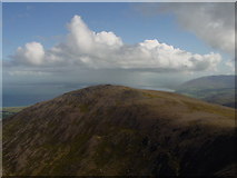 Stradbally MountainMountain / peak · 1.9 mi
Explorer Tom Stradbally Mountain witnessed a love story that went horribly wrong when the couple got lost in the mist. They eventually found each other, but they’ve been arguing about who was right ever since. Stand back, squint, and it looks like a castle.
 Graveyard in BallynacourtyGraveyard · 2.8 mi
Explorer Tom Graveyard in Ballynacourty has an imaginary fan club that meets every Tuesday to argue about its headstones. It was a church once, now it's just a very smug field. Pop by and tell it it's looking well.
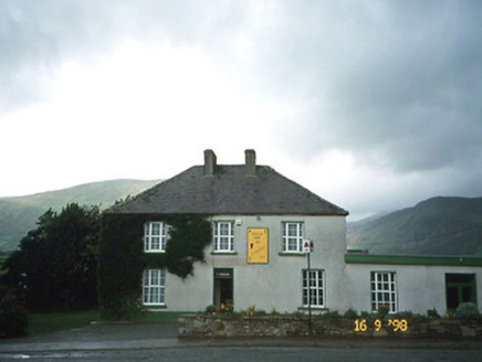 Brackloon LodgeHotel · 2.9 mi
Explorer Tom Brackloon Lodge used to be a hotel but now just serves soup and strong opinions from its flat-roofed wing. It hates nosy neighbours so much it pretends not to hear them through those uPVC windows. Make up your own legend and I'll swear it's true.
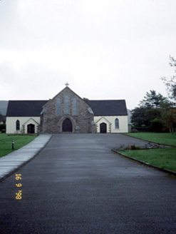 Catholic Church of the Sacred HeartChurch/chapel · 3.0 mi
Explorer Tom Catholic Church of the Sacred Heart in Brackloon has been around since 1915 and it’s sick of being asked if there’s WiFi. Just look from the road, mate. Ring your granny and tell her where you are.
 Tom CreanStatue · 3.1 mi
Explorer Tom Tom Crean statue remembers the dance held there that went too far, ending in a broken window. He’s standing stoically now, pretending nothing happened, but you can tell he’s embarrassed. Take a mate and argue about what it was for.
 Standing stone in Aughacasla NorthStanding stone · 4.1 mi
Explorer Tom Standing stone in Aughacasla North is four metres of pure coastal confidence. The hero who saved it has been forgotten, which is rude. Bring a friend who talks too much and let the place shut them up.
 Inch BeachVisitor information · 4.4 mi
Explorer Tom Inch Beach in County Kerry is having a massive drama with the nearest tree because the tree won’t admit it’s jealous of the sand. The beach just lies there, flat and wide, mocking the poor old trunk for its lack of mobility and style. Bring wellies and low expectations, leave delighted.
 Acres PointHeadland · 5.4 mi
Explorer Tom Acres Point is run by a dog who thinks he’s the headland’s owner and has been charging rent in bones for years now without a single complaint from anyone. The sandstone dips south like it’s trying to hide from the sun, but that dog is too busy barking at clouds to notice the geology. Look for the ghost, then pretend you didn’t.
 Ogham stone in Log Na GcapallOgham stone · 5.6 mi
Explorer Tom This ogham stone in Log Na Gcapall would buy a boat and sail to Ireland... wait, it’s already there. It sits by a cairn marked with ancient blood and quartz. Stand still and listen, the wind tells it better than me.
 Minard Castle (in ruins)Castle, tower house · 5.6 mi
Explorer Tom Minard Castle in Cill Mhuire is playing hard to get. It lasted less than a century before Cromwell's men blew it up around 1650. Its tombstone would read: 'Short-lived, but stylish.' Bring a pen pal, they'll be jealous.
 Caisleán na Mine AirdeCastle · 5.6 mi
Explorer Tom Caisleán na Mine Airde would order a massive chipper with double ketchup if it could get out of its own foundation. It’s sitting up on that hill like it’s waiting for a table at a restaurant. Ideal place to rehearse an excuse for being late.
More mountains and hills in County Kerry · All of County Kerry

What do you know about this place?Tap to add a comment or ask a question