
What is recorded here
Places near here
Picture notes
- Computer-made picture. It does not show this walking route.
- Computer-made picture. It does not show this monument.
- Computer-made picture. It does not show this mountain top.
- Carroll Pierce, Wikimedia Commons · CC BY-SA 2.0
- Michael Dibb, Geograph · CC BY-SA 2.0
- DAYVEHUSE, Wikimedia Commons · CC BY-SA 4.0
- National Inventory of Architectural Heritage
- N Chadwick, Geograph · CC BY-SA 2.0
 Fox’s Rock Bullaba (Bulben) LoopOfficial walking route · 1 ydComputer-made picture
Explorer Tom Fox’s Rock Bullaba Loop is nine point three kilometres of pretending you’re an explorer. It’s moderate, which means your knees will be moderate too by the end. Ten minutes here and you'll have a yarn for the pub about that one time.
 Mound in LenanMound · 370 ydComputer-made picture
Explorer Tom The Mound in Lenan is a solid oval of dark earth and stones, sitting right where the Camowen and Owenerk rivers meet. It’s been chopped on the NE side, which is a bit cheeky for a historic pile. But it still stands proudly in the fields, waiting for you to spot its ancient shape.
 CrocklaurkMountain / peak · 610 ydComputer-made picture
Explorer Tom Crocklaurk looks like it’s been waiting for a storm to make its entrance dramatic. It’s got that moody, unapproachable vibe that influencers love but hikers hate. Ideal for a moody photo you'll pretend wasn't posed at all.
 Rock art in SharagoreRock art · 1644 ydComputer-made picture
Explorer Tom Rock art in Sharagore is a bit of an enigma because we don’t have much detail on it yet. It’s officially recorded, but the specifics are still locked away, leaving us to wonder what shapes are carved there. I bet those ancient artists had some pretty wild stories to tell through their chisels.
 CroaghcarraghMountain / peak · 1655 ydComputer-made picture
Explorer Tom Croaghcarragh is trying to blend into the background scenery, failing spectacularly because it’s a mountain. It looks like it’s judging your life choices from the top. Go before the tourists find out, or at least before they put up a sign that says 'Selfie Here'.
 Mamore GapViewpoint · 1.0 mi
Explorer Tom Mamore Gap is a spot where the wind whispers your deepest secrets to the clouds. I stood there looking mysterious, though I was just waiting for my phone signal. Stand there long enough and someone will ask if you're lost.
 Gap of Mamore ViewpointViewpoint · 1.7 mi
Explorer Tom Gap of Mamore Viewpoint is hiding in plain sight on the Wild Atlantic Way. The mist rolls in there like it owns the place, which it probably does. Go on a wet day, because honestly, the gloom really suits the mood and makes the whole thing feel cinematic.
 Gortleck Catholic ChurchChurch/chapel · 1.7 mi
Explorer Tom Gortleck Catholic Church has a cross-shaped stone with cupmarks that look like someone used a spoon to dig tiny holes. I picture the stone wondering if those were actually fingerprints from a very sticky giant’s hand. Did it get itchy?
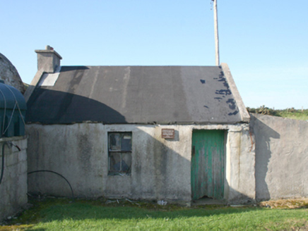 forge/smithy1.7 mi
Explorer Tom Forge or smithy in Lenan was built around 1840. Its plaque remembers the crew of Wellington Bomber W5653, who died in the Urris crash on 11 April 1941; their bodies were laid in this forge before transfer to Dunree and burial in Britain. I let the plaque speak here.
 Lenan LoopOfficial walking route · 1.8 miComputer-made picture
Explorer Tom Lenan Loop is one point nine kilometres of moderate walking that feels longer because the dog keeps sniffing everything. It’s short enough for a quick dash if you’re in a hurry to be bored. Bring the dog, it'll have opinions on the path quality.
 Dunree CentreMuseum · 3.0 mi
Explorer Tom Dunree Centre is one building in the Fort Dunree grounds, where the fort's story takes six exhibition chapters to tell. I would give them proper time: a place that has watched over Lough Swilly for so long deserves more than a quick look at the view.
 Dunree HeadHeadland · 3.0 mi
Explorer Tom Dunree Head is where the legend runs out and the map begins. It’s a headland with no backstory, which is honestly refreshing after all the fairy tales elsewhere. Bring your own legend, I've run out.
More walking routes in County Donegal · All of County Donegal

What do you know about this place?Tap to add a comment or ask a question