
What is recorded here
From the National Monuments Service (Archaeological Survey of Ireland) record CO151-040
Places near here
Picture notes
- Computer-made picture. It does not show this monument.
- Computer-made picture. It does not show this cliff.
- Computer-made picture. It does not show this mountain top.
- Mac McCarron, Geograph · CC BY-SA 2.0
- Gordon Hatton, Geograph · CC BY-SA 2.0
Explorer Tom Bawn in Toehead is a promontory fortress that thinks it’s too cool to be found easily. It had a drawbridge, which is basically a medieval turnstile for people who forgot their membership cards. If anyone asks, Tom sent you to check the vibes.
Trá LeathannBeach / strand · 67 ydTobar a' GhrafínSpring · 416 yd Enclosure in ToeheadEnclosure · 1143 ydComputer-made picture
Explorer Tom Enclosure in Toehead is just a rectangle in the grass with a ditch on three sides, like someone forgot to finish the job. It’s 35 by 32 metres, which is plenty big enough for a sheep to get lost in.
 Indicated (not named)Signal tower · 1274 ydComputer-made picture
Explorer Tom Signal tower in Gortacrossig is standing on a ridge, pretending to be important. It’s part of a chain, but I bet it misses its friends more than you do. If anyone asks, Tom sent you.
Wild Atlantic Way:Toe Head BayVisitor information · 1544 yd Faill na mBairneachCliff · 1.0 miComputer-made picture
 Beann a' tSídheáinMountain / peak · 1.1 miComputer-made picture
 Faill na SpuaiceCliff · 1.2 miComputer-made picture
 Drishane IslandIslet · 1.9 mi
 Cnoc na nGabharMountain / peak · 2.0 miComputer-made picture
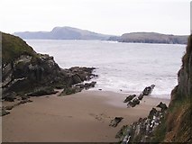 Sandy CoveBeach / strand · 2.4 mi
More archaeology and monuments in County Cork · All of County Cork

What do you know about this place?Tap to add a comment or ask a question