
Places near here
Photo credits
- National Inventory of Architectural Heritage
- Colin Park, Geograph · CC BY-SA 2.0
- Roger Diel, Geograph · CC BY-SA 2.0
Explorer Tom An enclosure in Derry where the information is 'not been uploaded,' which is very modern for an old site. I suspect it’s shy because it knows it’s not as cool as the others nearby. Best seen with a hangover and a sausage roll; the carbs help you ignore the lack of detail.
Calluragh WoodForest · 1418 ydExplorer Tom Calluragh Wood would spill all its secrets after three pints, mostly about the time it lost a bet to a hedgehog. It keeps its mouth shut during business hours but gets quite gossipy once the sun goes down. Go on a wet day, it suits the mood.
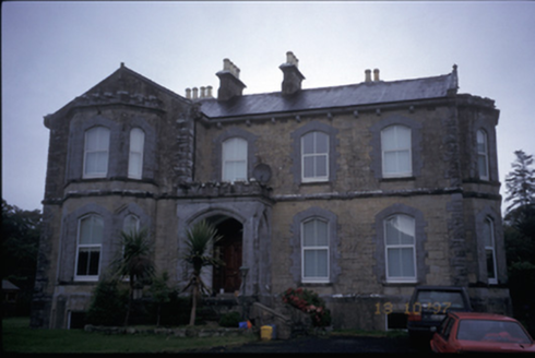 Hurdlestown HouseHouse · 1569 yd
Explorer Tom Hurdlestown House is dated 1871 but looks like it tried to be a castle and lost the budget halfway through. It’s got crenellated bits that are purely for show, I bet you that. Look for the ghost, then pretend you didn't, because he might be shy and wearing a tutu.
IndicatedEnclosure · 1686 ydExplorer Tom Enclosure in Drummin was built on a bargain where someone traded their firstborn cat for a really nice view of the valley. The cat is still around somewhere, judging people from the hedge, and the view hasn't changed one bit since then. It’s the most boring deal ever made, but hey, cats are good listeners. Great spot to propose. Or at least to propose lunch.
Deerpark WoodForest · 1.3 miExplorer Tom Deerpark Wood has a retirement plan involving becoming a very fancy compost heap in about three hundred years. It’s already started slowing down its growth to prepare for the big nap. Toast it with a cup of tea and move on to the next.
DoonHeritage attraction · 1.5 miExplorer Tom This second Doon is secretly proud of one specific potato that refuses to rot, treating it like a precious jewel in its pocket. It’s been guarding this spud since the last ice age, waiting for someone to appreciate its culinary legacy. Bring a map, get lost anyway, that's the fun.
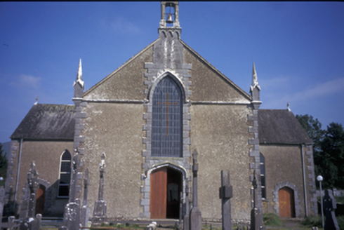 Saint Mary's Catholic ChurchChurch/chapel · 2.4 mi
Explorer Tom Saint Mary's Catholic Church in Kilbane is a Gothic Revival beauty from around 1850 with some very serious pinnacles. It’s got replacement uPVC windows, which feels like wearing a tuxedo to a barbecue. Snap one photo, then put the phone away and actually look.
Broadford Mass RockMemorial · 2.4 miExplorer Tom Broadford Mass Rock in County Clare offers a shortcut that is definitely not a shortcut because you have to climb up a hill just to walk past the rock. It’s got that ‘I’m important’ energy going on, even though it’s basically just a big stone with good PR and a bit of history attached. Have a wander and a wonder.
Mass RockMemorial · 3.9 miExplorer Tom Mass Rock in County Clare would be a terrible history teacher because it’s too stubborn to turn around and show you what it saw from that angle. It just sits there judging your posture while pretending it knows exactly why it was placed as a memorial spot. Bring curiosity, leave with a better story than mine.
 MoylussaMountain / peak · 4.4 mi
Explorer Tom Moylussa is Clare's highest point at 532 metres, and I will let it enjoy the title without asking for a taller rival. The mountain rises west of Lough Derg, above forest and open moor. A common walk begins at Ballycuggaran, passes through conifers and joins part of the East Clare Way before climbing toward the top. A shale path now helps walkers reach the summit marker. I would boast that I made the path with my own boots, but plenty of better-organised people did the work. Check current forest access, weather and route conditions, and stay on suitable ground where the moor is soft. From the top, turn toward Lough Derg and the Shannon country. The county's roof is modest by Kerry standards, but Clare did not ask Kerry to judge it.
 Ballynahinch Castle (in Ruins)Castle, unclassified · 4.7 mi
Explorer Tom Castle in Ballymulcashel has a curse for anyone who doesn't wave at it first. It’s perched high up, so if you ignore it, your phone loses signal. Don't be rude to the tower house, it remembers everything. Bring your own legend, I've run out.
 Aharinagh Castle (in ruins)Castle, unclassified · 5.3 mi
Explorer Tom Aharinagh Castle in Ballybrack feels like it was designed by a very angry mother-in-law who hated guests. The whole vibe is 'don't touch my stuff.' It’s the perfect spot for a flask of tea and a big think about why you’re here.
More archaeology and monuments in County Clare · All of County Clare

What do you know about this place?Tap to add a comment or ask a question