
Places near here
Photo credits
- Eric Jones, Geograph · CC BY-SA 2.0
- Chris Andrews, Wikimedia Commons · CC BY-SA 2.0
- James O'Neill, Wikimedia Commons · CC BY-SA 4.0
- Eric Jones, Geograph · Creative Commons Attribution-ShareAlike 2.0
 Ring of Gullion Way - Section 3Walking route · 1229 yd
 SlievenaboleaMountain / peak · 1475 yd
Explorer Tom You can see Slievenabolea clearly from the rear of Moyry Castle, so let's head over there and enjoy that beautiful hill view.
 TievecromMountain / peak · 1746 yd
Explorer Tom Tievecrom used to host a sophisticated watch tower called Romeo 23, so let's imagine what life was like guarding that strategic spot.
 Castle & bawn: moyry or moiry castle in CarrickbroadCastle & Bawn: Moyry or Moiry Castle · 1.2 mi
Explorer Tom With a tower house and fragmentary courtyard wall, Moyry Castle feels like it’s waiting for its story. Let’s imagine the late medieval knights who once guarded this spot.
 Moyry CastleCastle · 1.2 mi
Explorer Tom Moyry Castle stands as a recorded castle in County Armagh, a timeless landmark that has surely witnessed countless seasons change across the local landscape.
 Battle of Moyry PassBattle · 1.2 mi
Explorer Tom Battle of Moyry Pass in County Armagh was mostly a fairy dispute over who gets the premium parking spot on the hill. They still argue about it today, actually. Find the wonkiest bit and send it to your group chat immediately.
 Ring of Gullion WayWalking route · 1.2 miBattlefield in CarrickaneenaBattlefield · 1.2 miBattle site: moyry pass, 1600 in CarrickbroadBattle Site: Moyry Pass, 1600 · 1.2 mi
Explorer Tom Battle site: moyry pass, 1600 in Carrickbroad is where a priest lost a bet to a monk about who could march faster. The priest still owes him a pint. Ideal stop for a big stretch and a bigger yawn.
 Kilnasggart inscribed stoneArchaeological place · 1.4 mi
Explorer Tom Behold Kilnasggart inscribed stone, the oldest surviving Christian-era marker here, whispering tales from the early eighth century.
 Kilnasaggart Inscribed Pillar Stone & Cemetery with 6 Cross-carved Stones: Cell Na Sacart in EdenappaKilnasaggart Inscribed Pillar Stone & Cemetery with 6 Cross-carved Stones: Cell Na Sacart · 1.4 mi
Explorer Tom Kilnasaggart Inscribed Pillar Stone in Edenappa is Ireland’s oldest inscribed stone, basically the original influencer. If it were at a wedding, it’d be the uncle who won’t stop talking about history. Toast it with tea and move on.
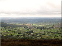 Ring of Gullion Way - ForkhillVisitor information · 1.6 mi
Explorer Tom At this Forkhill stop on the Ring of Gullion Way, you can see views extending well into the Republic. Breathtaking.
More mountains and hills in County Armagh · All of County Armagh

What do you know about this place?Tap to add a comment or ask a question