
What is recorded here
From the National Monuments Service (Archaeological Survey of Ireland) record GA010-024
Places near here
Photo credits
- Maker not stated on source page, www.pinterest.com
- Newbert12, Wikimedia Commons · CC BY-SA 4.0
- Maker not stated on source page, commons.wikimedia.org
- Britishfinance, Wikimedia Commons · CC BY-SA 4.0
- Alan Reid, Geograph · CC BY-SA 2.0
- Joebater at English Wikipedia, Wikimedia Commons · CC BY-SA 3.0
- Espresso Addict, Geograph · CC BY-SA 2.0
- Hajotthu, Wikimedia Commons · CC BY-SA 3.0
- Colin Park, Geograph · CC BY-SA 2.0
- dalvenjah on Flickr, Wikimedia Commons · CC BY-SA 2.0
- Maker not stated on source page, www.irishamericanmom.com
- Kahuroa, Wikimedia Commons · Public domain
 Tobersalrock Holy well (Site of)Holy well · 488 yd
Explorer Tom Tobersalrock Holy well in Foher is how many cups of tea it took to build. It’s gone now, but the church nearby still…
 Salrock ChurchChurch/chapel · 663 yd
Explorer Tom Salrock Church was built on a bargain where the devil traded good lighting for a slightly crooked steeple, which I…
 Fairy fort / stone ringfort in Lettergesh EastFairy fort / stone ringfort · 1536 yd
Explorer Tom Fairy fort / stone ringfort in Lettergesh East is an oval cashel on a small hill, commanding a pass between two loughs.…
 BenchoonaMountain / peak · 1.2 mi
Explorer Tom Benchoona and the nearest tree are in a massive drama; she thinks he’s blocking her view of the lake, and he thinks…
 Glassilaun BeachBeach / strand · 1.4 mi
Explorer Tom Glassilaun Beach lies near the mouth of Killary Harbour, where white sand opens towards the water and Mweelrea rises…
 GarraunMountain / peak · 1.4 mi
Explorer Tom Garraun sits above Lettergesh in north Connemara like a bald headed lookout who has forgotten to take his hat off. Its…
 Lettergesh BeachBeach / strand · 2.0 mi
Explorer Tom Lettergesh Beach on the Renvyle Peninsula spreads its sand beneath a grand Connemara skyline, with Mweelrea across the…
 Kylemore AbbeyMausoleum · 3.2 mi
Explorer Tom Kylemore Abbey’s mausoleum is the quiet cousin at the wedding, wearing yellow bricks that scream 'I’m different'. It…
 Silver StrandBeach / strand · 3.2 mi
Explorer Tom Silver Strand in County Mayo does some very strange things when nobody’s looking, like rearranging its own pebbles into…
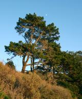 Monterey Pine3.4 mi
Explorer Tom Monterey Pine in County Galway once saw a fox try to climb it but get stuck halfway up because the branches were too…
 The WaterfallVisitor information · 3.5 mi
Explorer Tom The Waterfall is planning to spend its lotto win on a very expensive pair of swim trunks and a vacation to the moon…
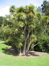 Cabbage tree3.6 mi
Explorer Tom Cabbage tree in County Galway looks like it’s waiting for a bishop who refused to visit because the leaves were too…
More archaeology and monuments in County Galway · All of County Galway

What do you know about this place?Tap to add a comment or ask a question