
What is recorded here
From the National Monuments Service (Archaeological Survey of Ireland) record CO026-074
Places near here
Picture notes
- National Inventory of Architectural Heritage
- Computer-made picture. It does not show this monument.
- Fattonyni, Wikimedia Commons · CC BY-SA 3.0
- Computer-made picture. It does not show this mountain top.
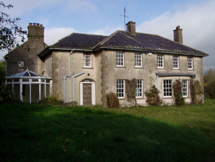 The GlenHouse · 378 yd
Explorer Tom The Glen in Killuragh had a fire in the 1950s and added a block, so now it’s got an asymmetry that screams ‘I’m different’. The carved gate piers are elegant enough to make you feel underdressed. Great job, but don’t let the new wing steal your thunder.
 Ritual siteRitual site, holy tree/bush · 403 ydComputer-made picture
Explorer Tom Killuragh Ritual Site is just a fallen tree that locals carry chips of to avoid drowning, which is a very specific superpower. It used to ring a bell at midnight when the wind blew, so it’s got a ghostly soundtrack. Perfect spot to practise your best tour-guide voice.
 Burial ground in KilluraghBurial ground · 421 ydComputer-made picture
Explorer Tom Burial ground in Killuragh is hiding behind a walled garden where a gravel walk used to run. It’s basically gone, but the local tradition says a church was here too. Bring curiosity, leave with a better story than mine.
 Fairy fort / earthen ringfort in KilluraghFairy fort / earthen ringfort · 505 ydComputer-made picture
Explorer Tom Fairy fort / earthen ringfort in Killuragh has a drainage pipe inserted across it! Plus a feeding trough and someone dug a hole looking for treasure. So we’ve got history, infrastructure, and greed all mixed up in one messy circle.
 Field boundary in KilluraghField boundary · 543 ydComputer-made picture
Explorer Tom A curved ditch visible only on Apple Maps? That’s not a boundary, that’s a digital ghost. The poet who fell in the nearby ditch probably wrote this line. Ideal place to rehearse an excuse for being late again.
 Fulacht fia in GarranacholeFulacht fia · 650 ydComputer-made picture
Explorer Tom Fulacht fia in Garranachole is a 24-metre circle of burnt stuff next to a pond. A stream flows north, but the grass hides most of it. Give me a shout if you spot any smoke!
 Enclosure in KilluraghEnclosure · 670 ydComputer-made picture
Explorer Tom Another Enclosure in Killuragh is just a diffuse parch mark suggesting a roughly circular shape. It’s vague and cloudy. Like a ghost that forgot its outline. You have to squint really hard at the aerial photos to see this one.
 Ring-ditch in KilluraghRing-ditch · 747 ydComputer-made picture
Explorer Tom Ring-ditch in Killuragh is playing hide-and-seek with me. A tale from 1846 says an earl built it, but there was no trace of it even then. Get there early and have it all to yourself.
Fulacht fia in KilluraghFulacht fia · 858 ydComputer-made pictureExplorer Tom Fulacht fia in Killuragh is buried in tillage, waiting for a plough to find its burnt secrets. It’s basically a prehistoric potato chip hiding under the soil. Walk past slowly like you’re in a film.
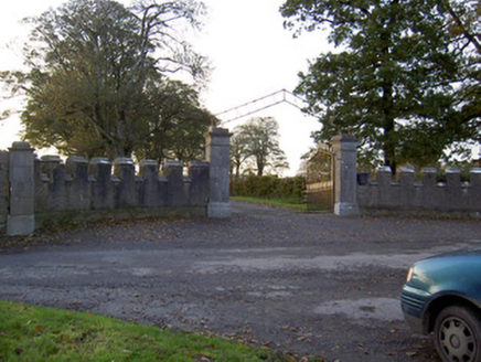 Castle KevinGates/railings/walls · 1258 yd
Explorer Tom Castle Kevin has entrance walls that look like a castle because they are crenellated. The limestone piers are carved so nicely you’d almost want to touch them, but don't.
 Killavullen CavesCave · 1.4 mi
 KnockwateareMountain / peak · 4.8 miComputer-made picture
More archaeology and monuments in County Cork · All of County Cork

What do you know about this place?Tap to add a comment or ask a question