Places near here
Photo credits
- P L Chadwick, Wikimedia Commons · CC BY-SA 2.0
- P L Chadwick, Geograph · CC BY-SA 2.0
- John M, Geograph · CC BY-SA 2.0
- National Inventory of Architectural Heritage
- dalvenjah on Flickr, Wikimedia Commons · CC BY-SA 2.0
- Vadim Manuylov, Wikimedia Commons · CC BY-SA 3.0
- Ulrich Hartmann, Geograph · CC BY-SA 2.0
- Nigel Cox, Geograph · CC BY-SA 2.0
- N Chadwick, Geograph · Creative Commons Attribution-ShareAlike 2.0
- Mike Searle, Wikimedia Commons · CC BY-SA 2.0
- Colin Park, Geograph · CC BY-SA 2.0
 CrannogHeritage attraction · 2.1 mi
Explorer Tom Crannog is a scale model of a lake dwelling that locals swear was actually built by a giant who just wanted a quiet weekend. It’s cute, but if you tell anyone I said the giant was polite, they’ll laugh. Bring a map, get lost anyway, that's the fun.
 Bonane Heritage ParkMuseum · 2.3 mi
Explorer Tom Bonane Heritage Park in Kerry has a fiddler who played all night and didn't stop until the sun came up, ruining everyone's sleep. It’s a museum of things that shouldn't have survived but did anyway because they were stubborn. Go on, count the windows and get it wrong like I did.
 Baurearagh MountainMountain / peak · 3.2 mi
Explorer Tom Baurearagh Mountain in County Kerry fooled the mapmakers into drawing it three kilometers away from where it actually is. They probably got lost in the mist and just guessed where it should be. It’s basically playing a long con on every hiker who trusts their GPS too much. It's the kind of place that makes a dull Tuesday interesting.
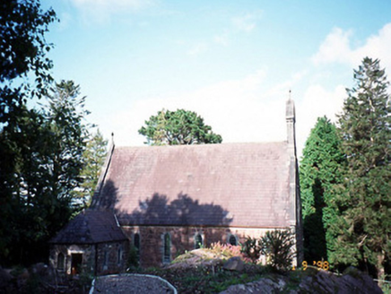 Dawros Catholic ChurchChurch/chapel · 3.3 mi
Explorer Tom Dawros Catholic Church is telling secrets after a few pints, likely about the bellcote or the purple slate roofs. Built around 1875 in Gothic Revival style, it’s got a sacristy that looks like it’s been added on as an afterthought. It probably thinks it’s more mysterious than it actually is. Ideal for a moody photo you'll pretend wasn't posed.
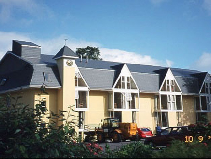 Riversdale HouseHouse · 3.3 mi
Explorer Tom Riversdale House gave up chocolate for Lent but kept its triple-gable attitude. Built in 1880, it now runs as a hotel for people who like old charm. Give it a pat on the way past, it's had a long life.
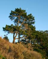 Monterey Pine3.8 mi
Explorer Tom A Monterey Pine in County Kerry claims it was friends with a famous singer who got lost here. The bird population is very skeptical about this story. Go back in winter, it's a different animal.
 Monterey Cypress4.0 mi
Explorer Tom This Monterey Cypress in County Kerry confused the map makers so badly they gave up and drew a circle. It’s definitely not where you think it is. Tell it a joke, it's been a long time since anyone did.
 Dinish IslandIslet · 4.1 mi
Explorer Tom Dinish Island smells like wet wool and old secrets, according to Tom's very reliable nose. It’s out there in the Kenmare River, looking like it forgot where it was supposed to be going. A proper spot for a flask of tea and a big think.
 Gleninchaquin WaterfallWaterfall · 4.2 mi
Explorer Tom Gleninchaquin Waterfall is one hundred and forty metres of pure, unfiltered attitude, absolutely refusing to be impressed by anything but its own thunderous volume. The local sheep stare at it with a mix of respect and deep existential confusion every single day. Perfect spot to practise your best tour-guide voice.
 Graveyard4.2 mi
Explorer Tom Graveyard in Killowen would describe the 1800s to a teenager as ‘slow Wi-Fi’. It’s still standing strong while everything else crumbles around it. Visit, then text me what you think. I'll pretend to read it.
 Dunkerron CastleCastle · 4.3 mi
Explorer Tom Dunkerron Castle near Kenmare has four storeys and more changes of owner than I have excuses for being late. Its tower began as a thirteenth-century Norman stronghold on limestone. Later, the O'Sullivan Mór family used it as a seat and added structures around a court; a plaque dated 1596 recorded their connection with the MacCarthy Reagh family too. Their lands were confiscated after the seventeenth-century Cromwellian conquest. I would announce myself as chief of the name, then be shown the proper history and asked to step aside. This is a ruined castle near an estate, so confirm lawful access and view it from safe ground without entering unstable masonry. Notice how the tower and later court work together. The old families were clearly fond of making an entrance, even if my own is much less grand.
 KnocknamanaghMountain / peak · 4.5 mi
Explorer Tom Knocknamanagh took forty-seven cups of tea to build, according to the local lore, which explains why it looks so slightly damp all year round. The architects were clearly hydrated, but the structural integrity is questionable at best, let’s be honest about that. Stop the car, it's worth the hazard lights.
More mountains and hills in County Kerry · All of County Kerry

What do you know about this place?Tap to add a comment or ask a question