What is recorded here
The official Northern Ireland wreck record identifies Daybreak (prob.) as Steamship. It was lost in 1917. Recorded depth: 53-35m. Recorded condition: Intact (5m high), upright. Bow is detached lying close to the wreck at 90deg, bridge collapsed.
A wreck point does not grant access or permission to dive, enter land, disturb the site or recover anything. Check current law and local conditions first.
Places near here
Photo credits
- Aubrey Dale, Wikimedia Commons · CC BY-SA 2.0
- Eric Jones, Geograph · CC BY-SA 2.0
- Oliver Dixon, Geograph · CC BY-SA 2.0
- Oliver Dixon, Wikimedia Commons · CC BY-SA 2.0
- Rossographer, Geograph · CC BY-SA 2.0
- Rossographer, Wikimedia Commons · CC BY-SA 2.0
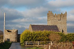 Kirkistown CastleCastle · 5.0 mi
 Kearney Coastal Walk, KearneyWalking route · 5.1 mi
 Burial IslandIslet · 5.7 mi
 Burr PointHeadland · 5.8 mi
 Quintin CastleCastle · 6.5 mi
 Quintin CastleCountry House · 6.5 mi
 Windmill HillMountain / peak · 6.6 mi
 Millin Bay CairnArchaeological place · 7.0 mi
 Glastry Presbyterian ChurchChurch · 7.1 mi
 Two Early Christian Churches: Churches of Dere in DerryTwo Early Christian Churches: Churches of Dere · 7.1 mi
 Corrog WoodWood · 7.7 mi
 Medieval Church & Graveyard: Ballytrustan; Thrustaynistone in BallytrustanMedieval Church & Graveyard: Ballytrustan · 7.8 mi
More wrecks and historic events in County Down · All of County Down
What do you know about this place?