
What is recorded here
From the National Monuments Service (Archaeological Survey of Ireland) record CO060-145
Places near here
Photo credits
- National Inventory of Architectural Heritage
- Sole Origami, Wikimedia Commons · CC BY-SA 4.0
- Maker not stated on source page, it.pinterest.com
- Maker not stated on source page, www.pinterest.com
- Maker not stated on source page, irelandyes.wordpress.com
- Maker not stated on source page, mademoiselleruta.com
- Kmcnamee, Wikimedia Commons · CC BY-SA 4.0
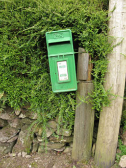 post box1093 yd
Explorer Tom Post box in Inchaleagh is a little cast-iron guy from 1950 standing opposite the church. It’s got Celtic Revival…
 St John the Baptist ChurchOfficially recorded historic building · 1167 yd
Explorer Tom St John the Baptist Church was nearly sold for a horse because someone thought the pinnacles were decorative horse…
 Fairy fort / earthen ringfort in CoolgarriffFairy fort / earthen ringfort · 1188 yd
Explorer Tom This huge Fairy fort / earthen ringfort in Coolgarriff was 200 feet across back in the day! Now it’s levelled and…
 Anomalous stone group in CoolgarriffAnomalous stone group · 1265 yd
Explorer Tom Anomalous stone group in Coolgarriff was three stones forming a triangle, one standing upright at the apex. Now there’s…
 Leades HouseCountry house · 1412 yd
Explorer Tom Leades House is a small country house with big dreams and tall windows. The symmetrical chimneys are doing their best…
Fairy fort / earthen ringfort in Knockglass (muskerry East By.)Fairy fort / earthen ringfort · 1.2 miExplorer Tom Fairy fort / earthen ringfort in Knockglass is planning its retirement by slowly dissolving into a nice, flat meadow.…
 Standing stone in Drombeg (muskerry East By.)Standing stone · 1.2 mi
Explorer Tom Standing stone in Drombeg has packed its bags and left town, taking all its mystery with it. It’s just a memory now…
 Church (Site of)Church · 1.2 mi
Explorer Tom Church in Leadawillin is in a field named Chapel Field, next to a rock outcrop called Donnell's little rock. The site…
Fairy fort / earthen ringfort in Curraghawaddra (muskerry East By.)Fairy fort / earthen ringfort · 1.4 miExplorer Tom Fairy fort / earthen ringfort in Curraghawaddra is hiding behind its dry drain like it’s shy. Someone dug a ditch right…
 Dolmen (Remains of)Standing stone · 1.4 mi
Explorer Tom Dolmen (Remains of) in Rusheen is leaning so far west that it looks like it’s trying to escape the field and run for…
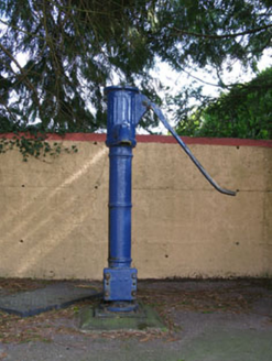 water pump1.5 mi
Explorer Tom Water pump in Rusheen lost its cap but keeps its curved handle. It’s been disused for a bit now, opposite the school.…
 Aghinagh GAA pitchGAA ground · 1.6 mi
More archaeology and monuments in County Cork · All of County Cork

What do you know about this place?Tap to add a comment or ask a question