
What is recorded here
From OpenStreetMap (© OpenStreetMap contributors) n9666873693
Places near here
Picture notes
- Computer-made picture. It does not show this monument.
- National Inventory of Architectural Heritage
- Computer-made picture. It does not show this mountain top.
- Picture: Simpson's Bar & Restaurant
- Picture: Barrack Hill Town Park
- Kenneth Allen, Geograph · CC BY-SA 2.0
- Kenneth Allen, Wikimedia Commons · CC BY-SA 2.0
 Fairy fort / ringfort in Machaire Dromann (tc Fánaid Thuaidh)Fairy fort / ringfort · 1189 ydComputer-made picture
Explorer Tom Fairy fort / ringfort in Machaire Dromann is sitting on the east bank of the Glenna Gannon river, where the maps once drew a single ring. No trace survives now, though a level patch of ground might mark its spot. I bet the fairies left before the surveyors got their pencils ready.
 OutlinedFairy fort / stone ringfort · 1343 ydComputer-made picture
Explorer Tom An Cheathrú Riabhach ringfort was described as a twenty-metre stone enclosure so overgrown that its southeast entrance was only a possibility. Tom likes a doorway that refuses to say whether it is a doorway at all.
 outbuilding1528 yd
Explorer Tom Outbuilding in Carrowmore is a rare c. 1800 survivor with a proper thatched roof held down by rope stays. It’s a single-cell beauty with whitewashed rubble walls, standing right on the road in Effishmore. Finding a thatched outbuilding this intact is like striking gold.
 Wedge tomb in An Cheathrú Riabhach (tc Gleann Ó Gceanann)Wedge tomb · 1.2 miComputer-made picture
Explorer Tom Wedge tomb in An Cheathrú Riabhach was literally pulled out of the peat by turf cutters in 1980. It’s a wedge-shaped gallery that narrows toward the east, sitting right next to a stone circle. It’s wild to think this whole history was just rotting away under the bog before.
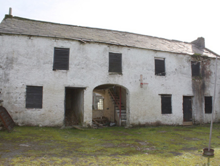 Hollymount HouseOutbuilding · 1.7 mi
Explorer Tom Hollymount House outbuilding has been guarding the rear of the estate since c. 1850, its roughcast rubble walls sturdy enough to survive most renovations. The segmental carriage arch and those timber louvers give it a proper workmanlike dignity that modern sheds just don’t have. It’s a solid reminder that servant quarters were built to last, not just look pretty.
 StoolaryMountain / peak · 2.0 miComputer-made picture
Explorer Tom Stoolary is a bit of a mystery, isn't it? I can only guess that its name might come from some old Gaelic story about a stone seat or a sturdy tree, sitting quietly in County Donegal.
 Simpson's Bar & RestaurantPub · 2.3 mi
Explorer Tom Simpson's Bar & Restaurant in Carndonagh is probably full of people pretending to be tourists. Grab a drink before they realize you're actually lost, buddy!
 Barrack Hill Community GardensGarden · 2.5 mi
Explorer Tom Follow the growers on Barrack Hill and you will find sixteen raised beds and three polytunnels. One starts the seedlings; the other two keep things growing. I could claim to know their secret for a good tomato, but the gardeners would catch me bluffing before I got through the gate. These are working plots, so ask the committee before going in.
 GrinlieveMountain / peak · 2.6 miComputer-made picture
Explorer Tom Grinlieve stands in County Donegal, a peak that seems to be grinning at the mapmakers from an unknown distance. The name sounds like a sneeze trapped in a woolly hat, so I suspect it is just holding its breath until someone actually shows up.
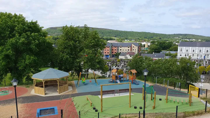 Barrack Hill Town Park PlaygroundChildren's playground · 2.6 mi
Explorer Tom At Barrack Hill, little legs get the climbing frames, swings, balance beams and monkey bars. The roundabout was designed to include more children, and older ones have their own obstacle trail nearby. If I were seven, I would call the monkey bars a test of courage. If I were a parent, I would be looking for the covered shelter. Carndonagh's park committee says local families helped shape the refurbished playground, and the older children's activity area reopened in 2023.
 Farren's RestaurantRestaurant · 2.6 mi
Explorer Tom Farren's Restaurant is serving up mystery meat with a side of confusion. I bet their specials change faster than my mood swings do every Tuesday.
 CuldaffOfficial bathing water · 5.4 mi
Explorer Tom Culdaff Beach looks as if three pieces of the map agreed to meet for tea: dunes to the west, two rock outcrops to the southeast, and the Culdaff River to the northwest. The sand has quite a supporting cast. This protected coast deserves a gentle visit.
More mountains and hills in County Donegal · All of County Donegal

What do you know about this place?Tap to add a comment or ask a question