
Places near here
Photo credits
- Kenneth Allen, Wikimedia Commons · CC BY-SA 2.0
- Kenneth Allen, Geograph · CC BY-SA 2.0
- Kenneth Allen, Geograph · Creative Commons Attribution-ShareAlike 2.0
- R0025693, Wikimedia Commons · CC BY-SA 4.0
_-_geograph.org.uk_-_2415758.jpg/250px-Cairn,_Altmore_(1)_-_geograph.org.uk_-_2415758.jpg "Photo: Kenneth Allen, Wikimedia Commons · CC BY-SA 2.0") Court tomb: long cairns or giant's graves in Altmore Alias BarracktownCourt Tomb: Long Cairns or Giant's Graves · 2.6 mi
Court tomb: long cairns or giant's graves in Altmore Alias BarracktownCourt Tomb: Long Cairns or Giant's Graves · 2.6 miExplorer Tom Court tomb: long cairns or giant's graves in Altmore Alias Barracktown is where a priest lost a bet over sheep counting. He hasn’t spoken since. Best enjoyed with a bag of chips and no plans.
 Standing stone in CloghfinStanding Stone · 4.2 mi
Explorer Tom Standing stone in Cloghfin was actually the escape route for its first owner, who ran off when things got too political in the Bronze Age village council. He probably packed a bag of potatoes and never looked back, leaving his rock friend behind. Pack a picnic and an excuse.
 Altamuskin Post OfficeHouse · 4.3 mi
Explorer Tom Altamuskin Post Office in County Tyrone was allegedly built using the steam from ten thousand cups of tea, which explains why it smells like wet wool and regret even today. It’s a house now, but it still holds its head high like it’s waiting for a letter that never arrived from 1905. Tell the kids it's a castle. Close enough.
 Parkanaur Manor HouseCastle · 5.2 mi
Explorer Tom Parkanaur Manor House rates every visitor on a strict scale from 'too loud' to 'interesting enough to keep'. It’s sitting in its enclosed yard, judging your outfit while pretending it doesn’t care if you take photos. Stick around for the light changing, it's a show.
 Upper Clonaneese Presbyterian ChurchChurch · 5.3 mi
Explorer Tom Upper Clonaneese Presbyterian Church once hosted a dramatic incident where a sheep wandered in and sat on the organ during Sunday service, causing chaos. It’s a Grade B church that has certainly seen some weird stuff over the years without losing its cool. Pop by and tell it it's looking well.
 Graveyard: relignaman or relicknaman from relig na mban The Women's' Graveyard in CarrickmoreGraveyard: relignaman or relicknaman from relig na mban The Women's' Graveyard · 5.6 mi
Explorer Tom The Women's Graveyard in Carrickmore would describe the 1800s to a teenager as 'vibes were strong but the fashion was terrible'. It’s a small enclosure with big opinions on how you should dress. Bring your own legend, I've run out.
 C17th house & bawn, possibly on site of earlier fort: castle caulfield in Lisnamonaghan, CastlecaufieldC17th house & bawn, possibly on site of earlier fort: castle caulfield · 5.8 mi
Explorer Tom C17th house & bawn, Possibly on site of earlier fort: castle caulfield in Lisnamonaghan thinks it's better than the famous ones because it has 'possibility' written all over it. It’s basically a seventeen-century draft that never got finished and now lives with its imaginary ancestors. Make a wish, it's had centuries of practice.
 Graveyard in GlenchuilGraveyard · 5.8 mi
Explorer Tom Graveyard in Glenchuil sits on top of a hill where the builder was clearly thinking about lunch while laying out the plots. It’s visible from every angle, which is either very impressive or terribly embarrassing depending on who you ask. Go on a wet day, it suits the mood.
 Medieval Parish Church; Graveyard also Site of C13th Battle: Carnteel Church in CarnteelMedieval Parish Church · 6.9 mi
Explorer Tom Medieval Parish Church, Graveyard also Site of C13th Battle: Carnteel Church in Carnteel was saved by a hero so unimportant nobody even bothered to write down his last name. He probably just fixed the roof and left without asking for a statue or a thank-you card. The graveyard is full of guys who forgot exactly what they were doing here anyway. Ideal stop for a big stretch and a bigger yawn
 Ranfurly HouseMuseum · 8.4 mi
Explorer Tom Ranfurly House is planning its retirement by turning into a really fancy bed and breakfast where the ghosts charge extra for Wi-Fi access. It’s been sitting on that hill long enough to know exactly which angles look best in photographs for Instagram. Hang around long enough and you’ll hear a story from a local.
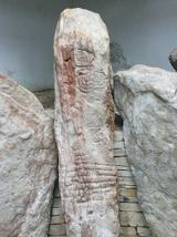 KnockmanyArchaeological place · 9.3 mi
Explorer Tom Knockmany has stone patterns so old I would be foolish to pretend I can read their secret message. The passage tomb near Augher dates to around 3000 BC. Thirteen sandstone uprights remain, and three carry rare carved circles, spirals and zigzags. A protective chamber and mound were built in 1959, so the art can be seen through the entrance gates without putting the stones at risk. The place has later tales of Queen Báine and Fionn mac Cumhaill, but those are stories, not labels left by the builders. I would happily tell one on the walk up and then let the carving hold my tongue. Check current site access, use the path and never touch or mark the stones. Some things have lasted precisely because later visitors learned to leave them alone.
 Drum Manor Forest ParkWood · 9.7 mi
Explorer Tom Drum Manor Forest Park claims its name comes from a drum, but I bet it’s actually named after a man who really liked drums and lived there. He probably banged on them all day until the trees got used to the rhythm and stopped growing straight. It's free, it's odd, what more do you want?
More mountains and hills in County Tyrone · All of County Tyrone

What do you know about this place?Tap to add a comment or ask a question