What is recorded here
From OpenStreetMap (© OpenStreetMap contributors) n3768881928
Places near here
Photo credits
- Kenneth Allen, Geograph · Creative Commons Attribution-ShareAlike 2.0
- Ian Paterson, Wikimedia Commons · CC BY-SA 2.0
- National Inventory of Architectural Heritage
- Robert Bone, Wikimedia Commons · CC BY-SA 2.0
- Kenneth Allen, Wikimedia Commons · CC BY-SA 2.0
- Patrice78500, Wikimedia Commons · Public domain
- Kenneth Allen, Geograph · CC BY-SA 2.0
- Rod Grealish, Geograph · CC BY-SA 2.0
- Eric Jones, Geograph · CC BY-SA 2.0
- louise price, Wikimedia Commons · CC BY-SA 2.0
 Kingarrow National SchoolSchool · 1.8 mi
Explorer Tom Kingarrow National School wears its 1891 date on a plaque and leaves the ends of its roof rafters in view. It kept its original timber windows too. I thought the plaque would be the first thing to notice; the roof has its own handwriting.
 ScraigsMountain / peak · 2.3 mi
Explorer Tom Scraigs is recorded as a mountain in County Donegal, and the name just screams 'rugged and ready to rumble.' I’d guess it’s got a very dramatic silhouette that makes for a perfect backdrop when you’re feeling particularly poetic.
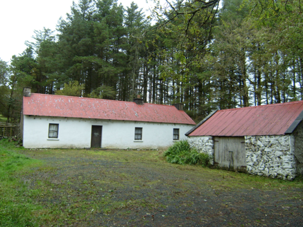 farmyard complex2.3 mi
Explorer Tom Farmyard complex in Largnalarkan hides metal pegs in its eaves, leftovers from a roped thatched roof. Built c.1830, it looks like a house still wearing the belt from an old hat. I bet the iron sheeting above is just a very practical winter coat.
 Giant's Grave Megalithic TombMegalithic tomb · 3.1 mi
Explorer Tom Giant's Grave Megalithic Tomb lies deep in boggy ground between Aghla and Scraigs. The recorded gallery was five metres long, with six stones on each side. A slab across one end might not have been part of its original roof. That uncertainty is more interesting than pretending the wet ground offers an easy look inside.
 Stone cairn, LougherrigPublicly named cairn · 3.9 mi
Explorer Tom A stone cairn at Lougherrig, captured in photos though its exact age remains unproven by this public record.
 Aghla MountainMountain / peak · 4.8 mi
Explorer Tom Aghla Mountain is a majestic peak in County Donegal, standing tall against the sky and inviting adventurers to test their skills on its rugged slopes.
 Páirc Naisiúnta Ghleann Bheatha - Glenveagh National ParkNature reserve · 6.4 mi
Explorer Tom Glenveagh National Park follows Lough Veagh through the Derryveagh Mountains, featuring easy trails and historic castle views.
 Teach Tábhairne an RileánPub · 6.8 mi
Explorer Tom Teach Tábhairne an Rileán in County Donegal has a mouthful of a name. Say it three times fast for me and tell me how you feel!
 Astelleen Burn WaterfallWaterfall · 9.1 mi
Explorer Tom Astelleen Burn Waterfall, meaning torrent or flood, sloping down three kilometers southwest of Glenveagh Castle is a hidden gem.
 Gweebarra BarPub · 9.6 mi
Explorer Tom Gweebarra Bar sits on a sharp bend in the N56, waiting for someone to drift into it. Snap a shot and don't let the road win!
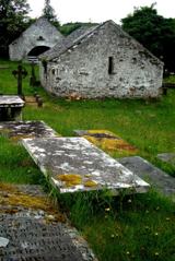 Inishkeel Graveyard near GlentiesGraveyard · 10 mi
Explorer Tom Inishkeel Graveyard near Glenties was rectangular in the older survey, but its south side sat on part of a roughly circular rise. Some of that rise lay beyond the west wall, about fifty metres across. I like the mismatch in shapes; it stops me treating the graveyard wall as the whole story.
 St. Connell's Museum and Heritage CentreMuseum · 10 mi
Explorer Tom St. Connell's Museum and Heritage Centre lets me go from an old courtroom to the cells below, then into stories of the workhouse and Donegal railways. That is a lot of Glenties history packed into one building. I would leave the cells to the displays and keep my own visit on the friendly side of the door.
More mountains and hills in County Donegal · All of County Donegal

What do you know about this place?Tap to add a comment or ask a question