
Places near here
Photo credits
- louise price, Wikimedia Commons · CC BY-SA 2.0
- Bart Whelan, Geograph · CC BY-SA 2.0
- Bart Whelan, Wikimedia Commons · CC BY-SA 2.0
- National Inventory of Architectural Heritage
- Kenneth Allen, Geograph · CC BY-SA 2.0
- Ronnie Nijboer, Wikimedia Commons · CC0
- louise price, Geograph · CC BY-SA 2.0
- Rossographer, Geograph · CC BY-SA 2.0
 Burial GroundGraveyard · 1.5 mi
Explorer Tom Burial Ground in Kilrean Upper is stacked with layers of history that refuse to stay quiet. You’ve got 12th-century sandstone window heads and a cross-slab with swastika patterns sitting right next to modern graves. It’s a bit of a chaotic archaeological buffet, so keep your eyes peeled for the odd carvings.
 lime kiln1.8 mi
Explorer Tom Lime kiln in Cronkeeran was built c.1860, and it still looks like it’s holding a giant bag of chalky dust. I bet the nearby cows sneezed so hard their udders popped when they ate the fertilizer.
 Ardara FortArchaeological place · 2.2 mi
Explorer Tom Ardara Fort is an archaeological place in County Donegal, named after the Fort Hill that gives the town its name. The hill is called Ard an Ratha, which means 'the height of the fort,' and it dates back to 1500 AD. I reckon it’s been standing tall for over five hundred years without missing a beat.
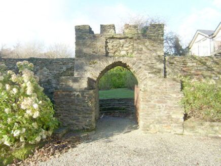 Wood HillWalled garden · 2.3 mi
Explorer Tom Wood Hill in Ardara is a walled garden with a circular bedding platform that looks like a giant target. It was built to serve Woodhill House, which has since altered its ways. The radiating pathways meet at the center, so if you get lost, just follow your nose back to the middle.
 Doherty'sPub · 2.5 mi
Explorer Tom Doherty's on Front Street smells like old boots and fresh Guinness mixed together in perfect harmony. I reckon the floorboards are sticky from decades of spilled stout and regret. Bring a jacket, it's never as warm as I promise.
 Green House BarPub · 2.5 mi
Explorer Tom Green House Bar in Donegal sounds suspiciously botanical, like they serve pints garnished with tiny plastic leaves and a stern lecture on photosynthesis. The locals probably think Dublin tourists are just confused weeds that need pruning. Look serious, nod slowly, you're basically an expert now.
 John DohertyMemorial · 2.6 mi
Explorer Tom John Doherty Memorial in County Donegal was built after forty-seven cups of tea were consumed in a single afternoon by very serious men. Nobody knows exactly what John did, but the monument looks like it’s trying to explain itself with its face. Look serious, nod slowly, you're basically an expert now.
 St. Connell's Museum and Heritage CentreMuseum · 3.3 mi
Explorer Tom St. Connell's Museum and Heritage Centre lets me go from an old courtroom to the cells below, then into stories of the workhouse and Donegal railways. That is a lot of Glenties history packed into one building. I would leave the cells to the displays and keep my own visit on the friendly side of the door.
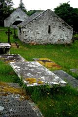 Inishkeel Graveyard near GlentiesGraveyard · 3.7 mi
Explorer Tom Inishkeel Graveyard near Glenties was rectangular in the older survey, but its south side sat on part of a roughly circular rise. Some of that rise lay beyond the west wall, about fifty metres across. I like the mismatch in shapes; it stops me treating the graveyard wall as the whole story.
 Wych Elm4.6 mi
Explorer Tom Wych Elm claims there’s a shortcut through its branches that saves twenty minutes, but nobody has ever actually found the exit yet. People get lost in the canopy and end up climbing down on the same side they started from. It’s a bit of a trickster with a green exterior. Bring a flask of something warm and a story to swap.
 Binn BhánMountain / peak · 4.6 mi
Explorer Tom Binn Bhán is recorded as a mountain / peak in County Donegal. It is hilarious that the ground goes from boggy to suddenly hard right at the top, like nature hit the brakes. I bet my boots would be utterly confused.
 Bonny Glen Wood - Bonny Glen walkOfficial walking route · 5.0 mi
Explorer Tom Bonny Glen Wood - Bonny Glen walk would bring a bottle of wine and a very serious face to any party it attended. It had a fire in 2011 and now acts like it’s been through therapy and came out stronger. A proper spot for a flask of tea and a big think.
More mountains and hills in County Donegal · All of County Donegal

What do you know about this place?Tap to add a comment or ask a question