
What is recorded here
From OpenStreetMap (© OpenStreetMap contributors) n3661637298
Places near here
Picture notes
- Computer-made picture. It does not show this monument.
- Shane Killen, Geograph · CC BY-SA 2.0
- National Inventory of Architectural Heritage
- Patrice78500, Wikimedia Commons · CC BY-SA 3.0
- John M, Geograph · CC BY-SA 2.0
- Kieran Evans, Wikimedia Commons · CC BY-SA 4.0
- Richard Webb, Geograph · CC BY-SA 2.0
- Computer-made picture. It does not show this playground.
- Computer-made picture. It does not show this mountain top.
- Rossographer, Geograph · CC BY-SA 2.0
 Cist in Dumhaigh MhórCist · 1448 ydComputer-made picture
Explorer Tom A cist in Dumhaigh Mhór once held bones and pottery on the Mulroy Bay shore. It was nine feet long, which is quite a stretch for a box of the dead. The sand around here is thick with midden material, so keep your eyes peeled.
 Midden in Dumhaigh MhórMidden · 1448 ydComputer-made picture
Explorer Tom Midden in Dumhaigh Mhór is a name that sounds like it’s shouting, yet it remains a quiet record waiting for more details. It’s a midden in County Donegal, and while we don’t have the specific finds listed here, the name alone suggests a place of some significance. I’d love to know if 'Mhór' refers to the size of the pile or just the scale of the mess.
 Trá na Rosann HostelHostel · 1578 yd
Explorer Tom Trá na Rosann Hostel is pretending to be a castle to impress you. Honestly, it's just a bed with a view of the void. Check if anyone's hiding under your mattress before you sleep!
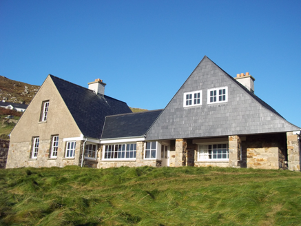 Tranarossan HouseHouse · 1579 yd
Explorer Tom Tranarossan House was designed by the distinguished architect, Edwin Lutyens. I bet he looked at this modest little hilltop spot and thought, 'Right, let's use half my best ideas.' It feels like a giant wearing very small, cozy slippers.
 Scoil Náisiúnta Míobhaigh [Meevagh National School]School · 1706 yd
Explorer Tom Scoil Náisiúnta Míobhaigh [Meevagh National School] carries 1923 on a plaque above its porch. The record says it later became a private house, while its old sash windows survive. Not every house has its first lesson written above the door.
 Cnoc na SleáMountain / peak · 1.2 mi
Explorer Tom Cnoc na Sleá means 'hill of the spear', though I would leave any spear firmly in the name. The guide also calls this small Donegal hill Crocknasleigh and points out its older Irish spelling. One hill, two ways to say it, and a very pointed name.
 Rosses StrandBeach / strand · 1.3 mi
Explorer Tom Rosses Strand is keeping it low-key with waves under a foot high, which is basically a nap for the sea. It’s resting its head on my shoulder right about now. Look up, the best bit is always higher than you think.
 The Murder HoleCave · 1.4 mi
Explorer Tom The Murder Hole in County Donegal is a cave with a bit of a dramatic reputation. It’s probably just a damp tunnel, but the name really sells the mystery. I’m sure there’s no actual murder, just vibes and bad lighting.
 Boyeeghter StrandBeach / strand · 1.4 mi
Explorer Tom Boyeeghter Strand bends into a horseshoe of sand near Melmore Head. That's a shape I can have fun with on the map: try drawing that curve in one sweep without lifting your pencil. The saved account warns of strong currents, so this is a map puzzle from me, not a swimming tip.
 Children's playground1.6 miComputer-made picture
Explorer Tom Children's playground in County Donegal would absolutely win a county fair for best display. The swings are probably judging your form right now, so keep it classy and don't overdo it. Have a nosey, but do it with extreme politeness.
 Gáinne MórMountain / peak · 1.8 miComputer-made picture
Explorer Tom Gáinne Mór is a mountain peak in County Donegal that keeps its access details firmly under wraps. The name sounds like a sneeze trapped in a woolly hat, so I suspect the summit is just holding its breath to see if anyone dares to climb it anyway.
 Beach HotelHotel · 2.6 mi
Explorer Tom Beach Hotel in County Donegal is right by the beach, which means sand everywhere, including in places you didn't know existed. Pack a vacuum cleaner just to be safe.
More mountains and hills in County Donegal · All of County Donegal

What do you know about this place?Tap to add a comment or ask a question