Places near here
Photo credits
- Andreas F. Borchert, Wikimedia Commons · CC BY-SA 4.0
- National Inventory of Architectural Heritage
- John M, Geograph · CC BY-SA 2.0
- Shane Killen, Geograph · CC BY-SA 2.0
- Rossographer, Geograph · CC BY-SA 2.0
- Patrice78500, Wikimedia Commons · CC BY-SA 3.0
- Kieran Evans, Wikimedia Commons · CC BY-SA 4.0
- Anne Burgess, Wikimedia Commons · CC BY-SA 2.0
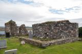 Mevagh Old ChurchChurch · 9 yd
Explorer Tom Mevagh Old Church was called an ancient ruined parish church in a 1622 record. The later survey describes parts of its east and west gables and south wall; near one corner lay a separate stone with twenty-three cup marks. I followed the church outline in the record and found another question beside it.
 Mevagh High CrossCross, High cross · 12 yd
Explorer Tom Mevagh High Cross is a stark, undecorated slab standing in the graveyard of a ruined medieval church. It’s simple and unadorned, which makes it feel like a quiet guardian overlooking the steep drop to Mulroy Bay. No fancy patterns here, just raw stone and history.
 Scoil Náisiúnta Míobhaigh [Meevagh National School]School · 925 yd
Explorer Tom Scoil Náisiúnta Míobhaigh [Meevagh National School] carries 1923 on a plaque above its porch. The record says it later became a private house, while its old sash windows survive. Not every house has its first lesson written above the door.
 Rosses StrandBeach / strand · 1.2 mi
Explorer Tom Rosses Strand is a beach where the waves at low tide are barely a foot high, which is basically the ocean taking a nap and pretending to be working hard. It would tell its younger self to stop trying so hard and just enjoy being a gentle lapping sound all day long. Toast it with a cup of tea and move on to the next.
 Trá na Rosann HostelHostel · 1.3 mi
Explorer Tom Trá na Rosann Hostel sits on the Rosguill Peninsula, claiming to be Ireland's most northerly bed. It’s basically a hunting lodge pretending to be fancy while you stare into the void. Take a mate and argue about what it was for.
 Beach HotelHotel · 1.5 mi
Explorer Tom Beach Hotel in County Donegal is right by the beach, which means sand everywhere, including in places you didn't know existed. Pack a vacuum cleaner just to be safe. Pretend you're a lost aristocrat, nobody will check your papers here.
 Cnoc na SleáMountain / peak · 1.6 mi
Explorer Tom Cnoc na Sleá means 'hill of the spear', though I would leave any spear firmly in the name. The guide also calls this small Donegal hill Crocknasleigh and points out its older Irish spelling. One hill, two ways to say it, and a very pointed name.
DowningsOfficial bathing water · 1.7 miExplorer Tom Downings gets to sit snug in Sheephaven Bay while Rosguill takes the Atlantic full in the face. I can almost hear the peninsula boasting about the arrangement. Donegal tourism lists windsurfing here, though the wind gets the final say on any plans for the water.
 The Murder HoleCave · 1.9 mi
Explorer Tom The Murder Hole would cope perfectly on a reality show by hiding in the corner and pretending the camera crew wasn’t there. It thinks its dark reputation is just great marketing and refuses to do any actual work or make eye contact with anyone. Spot the oldest stone and give it a silly name, because that’s what you should do.
 Cliffs at Lamb's IslandPublicly named cliff or headland · 2.4 mi
Explorer Tom Cliffs at Lamb's Island are the kind of cliff that would be the best man at a wedding, standing stiffly in the back while everyone else cries and laughs and spills wine everywhere. It just stands there looking dignified, wondering why anyone needs such a big fuss for what is basically two people agreeing to share a sofa. Pop by and tell it it's looking well.
 Cliffs on Ros GuillPublicly named cliff or headland · 2.4 mi
Explorer Tom Cliffs on Ros Guill gave up chocolate for Lent this year because it felt too guilty about being so visually stunning. It’s trying to be modest, but it’s still showing off its sheer drop quite effectively if you look closely enough. Visit, then text me what you think. I'll pretend to read it.
 Clonmass IslandIslet · 3.6 mi
Explorer Tom Clonmass Island in County Donegal was designed by a mother-in-law who wanted to make sure nobody could get comfortable there. It sits right next to Little Isle, acting like the strict older sister of the whole bay. Spot the oldest stone on the beach and give it a proper name.
More memorials and graveyards in County Donegal · All of County Donegal

What do you know about this place?Tap to add a comment or ask a question