What is recorded here
From OpenStreetMap (© OpenStreetMap contributors) n3794176086
Places near here
Picture notes
- Computer-made picture. It does not show this monument.
- Robert Bone, Wikimedia Commons · CC BY-SA 2.0
- National Inventory of Architectural Heritage
- Kenneth Allen, Geograph · CC BY-SA 2.0
- Joseph Mischyshyn, Geograph · CC BY-SA 2.0
- Rossographer, Wikimedia Commons · CC BY-SA 2.0
- Rossographer, Geograph · CC BY-SA 2.0
- No machine-readable author provided. Bogman assumed (based on copyright claims)., Wikimedia Commons · CC BY-SA 2.5
- N Chadwick, Wikimedia Commons · CC BY-SA 2.0
 Kilcashel Ecclesiastical EnclosureEcclesiastical enclosure · 191 ydTom: I’m here to help · Computer-made picture. It does not show this monument.
Explorer Tom Kilcashel Ecclesiastical Enclosure hides its secrets under about a metre of thick oyster shell deposits. The earth bank is eroded and partly bulldozed, but that shell layer screams medieval feast or rubbish dump to me. A hollow way leads away from it, so maybe someone was in a real hurry to leave those snacks behind.
 Midden in KilcashelMidden · 212 ydTom: I’m here to help · Computer-made picture. It does not show this monument.
Explorer Tom Midden in Kilcashel is a complete blank, with not even a whisper of what’s buried under that Donegal soil. It’s the ultimate 'check later' spot where your best move is just to wave at the landowner from a respectful distance and dream big.
 Carrickalahagh HeadlandPublicly named cliff or headland · 1.1 mi
Explorer Tom Carrickalahagh Headland is a cliff with a name that rolls right off the tongue and into the sea. It’s basically a big rock wall where the land gives up. If you’re standing there, don’t lean too far out; gravity is a bit cheeky down here.
 outbuilding1.4 mi
Explorer Tom Outbuilding in Shanaghan was built around 1860 with a rounded straw-thatch roof tied to stone pegs in its rubble walls. The inventory calls thatched outbuildings a rare survival. I thought such careful roofing would belong to the house; this work building has kept the fancy curve for itself.
 IllancreeveIslet · 1.6 mi
Explorer Tom Illancreeve sits off Laconnel, looking north like it’s waiting for a bus that never comes. It’s got serious character, even if it’s just a blob on the map. Stand where the owner stood and practise looking smug.
 Tramore StrandBeach / strand · 1.7 mi
Explorer Tom Rosbeg’s Tramore Strand has a whole sand department working behind it. A geological field guide describes dunes along this open coast and more by the Loughros Mór estuary, as if one set of dunes could not decide where to settle. This is the southern Tramore, not its namesake near Dunfanaghy.
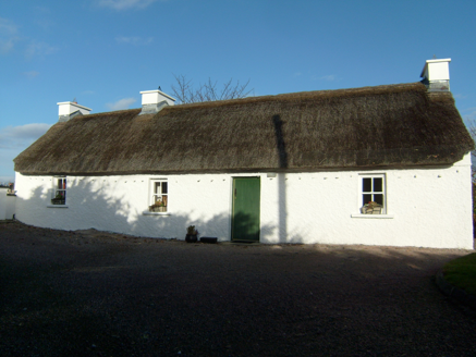 Beagh CottageHouse · 1.8 mi
Explorer Tom Beagh Cottage, built c.1830, keeps its thatch in place with cast-iron pegs that are now disused. Do they still click when the wind tries to lift the roof for a quick peek at the sky?
 Maghera StrandBeach / strand · 1.9 mi
Explorer Tom Maghera Strand put mountains behind the sand and caves in the cliffs, as if one dramatic backdrop would not do. The local beach guide places it beside Slievetooey and warns about high tides and currents. I would admire the cave mouths from a safe spot and let current local advice decide whether a closer look is sensible.
 Assaranca WaterfallWaterfall · 2.2 mi
Explorer Tom Assaranca Waterfall tumbles right beside the road between Ardara and Maghera, so lazy people can see it too. It’s best after heavy rain when it thunders like a grumpy god. Find a local and ask them the real story, then come back and tell me.
 Maghera WaterfallWaterfall · 2.3 mi
Explorer Tom Maghera Waterfall is just another entry for a waterfall in Donegal, likely looking very splashy and wet. We have no further details, so imagine it’s guarding a lost treasure. Have a sandwich here and call it a heritage lunch to impress your friends online.
 Maghera CavesSea caves · 2.4 mi
Explorer Tom Maghera Caves have enough openings to make me lose count: thirteen beside Maghera Strand, including Uaimh a' nDaoine, the Cave of the People. That name gives my imagination a full day's work. These are real sea caves, though, so I would keep my distance from the entrances.
 Teague's BarPub · 2.9 mi
Explorer Tom Teague's Bar in Ardara is probably named after Teague, who owns the place and hates tourists. Go in, order a drink, and try not to make eye contact with Teague's dog. It barks at everything shiny.
More mountains and hills in County Donegal · All of County Donegal

What do you know about this place?Tap to add a comment or ask a question