
What is recorded here
Recorded in 1981 as the 'remains of a large circular enclosure bounded by remains of an earth and stone bank best preserved from SW-W-N-E. The bank is eroded down to the interior from NW-N-E. From SW-W-N where the site is overlooked by a hillslope the bank drops appreciably into the interior and rises only very…
Read the whole record
From the National Monuments Service (Archaeological Survey of Ireland) record DG073-013005
Places near here
Photo credits
- Maker not stated on source page, commons.wikimedia.org
- Maker not stated on source page, en.wikipedia.org
- Maker not stated on source page, www.flickr.com
- Robert Bone, Wikimedia Commons · CC BY-SA 2.0
- Maker not stated on source page, za.pinterest.com
- National Inventory of Architectural Heritage
- Maker not stated on source page, traveller-eu.ru
- Joseph Mischyshyn, Geograph · CC BY-SA 2.0
- Rossographer, Wikimedia Commons · CC BY-SA 2.0
- Rossographer, Geograph · CC BY-SA 2.0
 Kilcashel GraveyardCemetery · 18 yd
Explorer Tom Kilcashel Graveyard was famously avoided by a bishop who claimed the ghosts were too loud for his delicate ears, which…
 Enclosure in KilcashelEnclosure · 272 yd
Explorer Tom Enclosure in Kilcashel is currently locked in a dramatic standoff with the nearest tree, arguing over who has the…
 Cross-inscribed stone in KilcashelCross-inscribed stone · 524 yd
Explorer Tom Cross-inscribed stone in Kilcashel apparently got pulled out of a hawthorn tree by someone taking photos! I bet they…
 Green IslandIslet · 1405 yd
Explorer Tom Green Island in County Donegal has a family tree that I’m pretty sure is just a bunch of rocks named after uncles who…
 Carrickalahagh HeadlandPublicly named cliff or headland · 1.2 mi
Explorer Tom Carrickalahagh Headland is a cliff that would teach history by throwing pebbles at you every time you get a fact wrong…
 Oileán an GhainimhIslet · 1.3 mi
Explorer Tom Oileán an Ghainimh in Donegal was nearly sold off for a horse in the 1800s because the seller couldn't spell its name…
 outbuilding1.3 mi
Explorer Tom Outbuilding in Shanaghan was built around 1860 with a rounded straw-thatch roof tied to stone pegs in its rubble walls.…
 Shanaghan GraveyardGraveyard · 1.4 mi
Explorer Tom Shanaghan Graveyard is marked on old maps, yet no trace of the church or burial ground survives. It’s sitting in rough…
 Tramore StrandBeach / strand · 1.8 mi
Explorer Tom Donegal owns enough places called Tramore to keep an explorer on his toes, so let us begin at the right one: the long…
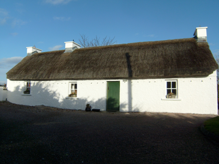 Beagh CottageHouse · 1.8 mi
Explorer Tom Beagh Cottage, built c.1830, keeps its thatch in place with cast-iron pegs that are now disused. Do they still click…
 Maghera StrandBeach / strand · 1.9 mi
Explorer Tom Maghera Strand has mountains behind its sand and sea caves tucked into the cliffs, as though Donegal looked at one…
 Assaranca WaterfallWaterfall · 2.2 mi
Explorer Tom Assaranca Waterfall makes a wonderfully bold entrance beside the coast road west of Ardara. After rain it throws water…
More archaeology and monuments in County Donegal · All of County Donegal

What do you know about this place?Tap to add a comment or ask a question