
What is recorded here
From OpenStreetMap (© OpenStreetMap contributors) n3763039315
Places near here
Picture notes
- Michael Dibb, Wikimedia Commons · CC BY-SA 2.0
- National Inventory of Architectural Heritage
- Computer-made picture. It does not show this monument.
- Computer-made picture. It does not show this mountain top.
- Computer-made picture. It does not show this playground.
- Rossographer, Geograph · CC BY-SA 2.0
- Alan Reid, Geograph · CC BY-SA 2.0
- Towel401, Wikimedia Commons · CC BY-SA 4.0
- Kenneth Allen, Geograph · CC BY-SA 2.0
_-_geograph.org.uk_-_5511292.jpg/250px-Cnoc_Fola_(Bloody_Foreland)_-_geograph.org.uk_-_5511292.jpg "Photo: Michael Dibb, Wikimedia Commons · CC BY-SA 2.0") Cnoc FolaMountain / peak · 1.1 mi
Cnoc FolaMountain / peak · 1.1 miExplorer Tom Cnoc Fola is the hill above the headland, with an old tale tying its name to Balor's blood. I picture a giant needing a very large handkerchief, though that belongs to legend, not my map. The map dot belongs on the hill.
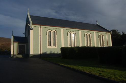 Teach Pobail Cholmcille Naofa [Saint Colmcille's Catholic Church]Church/chapel · 1.7 mi
Explorer Tom Saint Colmcille's Catholic Church in Brinlack has these zigzag Celtic chevrons staring at me from the porch window. I picture them marching in perfect little lines, refusing to step out of formation even when it rains.
 Signal Tower1.8 miTom: I’m here to help · Computer-made picture. It does not show this monument.
Explorer Tom The Signal Tower in Cnoc Fola is effectively gone, leaving just a ghost on an old map. It was part of a massive anti-French chain, but now it’s just empty pasture. Honestly, I’d love to stand there and check if the horizon still matches the 1834 survey.
 Burial in Mín LárachBurial · 1.8 miTom: I’m here to help · Computer-made picture. It does not show this monument.
Explorer Tom This burial in Mín Lárach is just a weird tuft of human hair found in a turf cut in 1987. Mr. Kennedy couldn’t even say exactly which bog it came from, so it’s like finding a single tooth in a haystack and calling it a skeleton.
 Cnoc na NaomhMountain / peak · 2.1 miTom: I’m here to help · Computer-made picture. It does not show this mountain top.
Explorer Tom Cnoc na Naomh means Holy Hill or something similar, which is suspicious for a place with no church. Pick a stone, any stone, and invent its biography; maybe it was once a bishop’s hat pin.
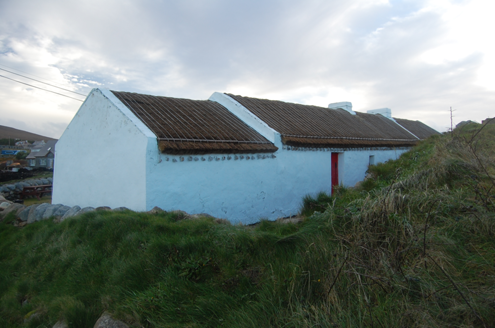 Teach MhuirisHouse · 2.2 mi
Explorer Tom Teach Mhuiris is wearing a thatched helmet held on by stone pegs and ropes. Built c.1860, I picture tugging one of those eave ropes to see if the whole roof lifts off like a giant, very damp hat.
 Children's playground2.5 miTom: I’m here to help · Computer-made picture. It does not show this playground.
Explorer Tom Private access means the owners are keeping their secrets close, probably for good reason. I bet the swings only move on full moons. A proper spot for a flask of tea and a big think.
 MagheraroartyOfficial bathing water · 2.7 mi
Explorer Tom Magheraroarty has pulled a fine trick on the map: Atlantic on one side of a sandy spit, Ballyness Bay on the other, Inishbofin up north. That is enough directions for one beach to manage. The western shore takes a strong Atlantic wash, so I would keep my admiration on dry sand.
 Inis Bó FinneIsland · 3.2 mi
Explorer Tom Inis Bó Finne is Donegal's island of the white cow, with old village ground and a view back to Errigal and Muckish. There is another Inishbofin off Galway, which is quite a long swim if you pick the wrong one. I would confirm the local boat before going.
 Oileán DúicheIslet · 4.3 mi
Explorer Tom Oileán Dúiche has a church ruin so small it is only fifteen feet long. The sole doorway stands five feet high but tapers as it rises, which is quite a fancy shape for such a tiny entrance. I reckon the builders really wanted to make sure you knew when you were getting in.
 Ostan Loch AltanHotel · 4.6 mi
Explorer Tom Ostan Loch Altan is pretending to be a grand hotel, but it looks more like a haunted shed with delusions of grandeur. Grab me a warm drink before the ghosts start billing us!
 Maggie Dan'sRestaurant · 4.6 mi
Explorer Tom Maggie Dan’s serves pizza, which is basically bread and cheese pretending to be Italian. If it tastes like regret, grab a slice for me anyway.
More mountains and hills in County Donegal · All of County Donegal

What do you know about this place?Tap to add a comment or ask a question