
Places near here
Photo credits
- A McCarron, Wikimedia Commons · CC BY-SA 2.0
- Anne Burgess, Wikimedia Commons · CC BY-SA 2.0
- National Inventory of Architectural Heritage
- Kenneth Allen, Geograph · CC BY-SA 2.0
- louise price, Geograph · CC BY-SA 2.0
- Eric Jones, Geograph · CC BY-SA 2.0
- Joseph Mischyshyn, Wikimedia Commons · CC BY-SA 2.0
- Mac McCarron, Geograph · CC BY-SA 2.0
- Mhdelaney, Wikimedia Commons · CC BY-SA 4.0
 Lough Aghnish Promontory FortPromontory fort, inland · 1184 yd
Explorer Tom Lough Aghnish Promontory Fort cuts off a peninsula with a stone wall that has a weird, angled entrance. The base is solid, but the top looks like modern repairs. It’s a bit of a puzzle why they built it exactly there.
 CroaghnamaddyMountain / peak · 1535 yd
Explorer Tom Croaghnamaddy in County Donegal is basically just a very arrogant hill that thinks it's a mountain. I'd bet my last pint there's a secret bakery up there, so bring biscuits, every good story needs biscuits.
 Meenacross National SchoolSchool · 1.2 mi
Explorer Tom Meenacross National School dates to 1875, and the porch plaque tells part of its later story: “Social Centre” was placed over “National School”. The carved name reads “Meenacrosh”. Its blocked Tudor-arch windows also show how a building can keep traces of earlier use.
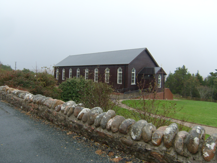 Saint Patrick's Catholic ChurchChurch/chapel · 1.2 mi
Explorer Tom Saint Patrick's Catholic Church in Meenacross looks like a sturdy wooden box from the outside. Built in 1930, its timber cladding hides a surprisingly bright, colorful interior. I reckon stepping inside feels like opening a plain gift to find confetti.
 Strand View BarPub · 1.6 mi
Explorer Tom Strand View Bar probably has a view of the sea and a lot of people staring at it. It's in Donegal, where the wind tries to steal your hat. Go look out the window and feel majestic.
Enclosure in An MachaireEnclosure · 2.1 miExplorer Tom The field called Rath Liath, or Grey Fort, in An Machaire holds a slightly sunken seven-metre square with a low grass-covered bank. Nearby earthworks made the surveyor consider a dwelling, while a terraced rise toward the shore might be a road. A possible stone circle was recorded in the same field. Several clues; none settles what the square was for.
 DooeyOfficial bathing water · 2.8 mi
Explorer Tom Dooey seems to have let the Gweebarra estuary and a headland book its two ends. Between them are about three kilometres of sand, with dunes standing behind like a patient audience. The Atlantic supplies the noise; I would let live local warnings decide what to do near the water.
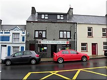 Teach Owenie BánPub · 3.3 mi
Explorer Tom Teach Owenie Bán in Dungloe has a sign that’s falling off the wall, which is very on-brand for the pub. The Irish name is fancy, but the pints are likely mediocre. Keep an eye out for ghosts.
 Drumlaghdrid HillMountain / peak · 3.7 mi
Explorer Tom Drumlaghdrid Hill stands in County Donegal with its access details currently unknown. A photograph shows the B7905 road climbing south-eastwards across its flank, six kilometres north of Lettermacaward. It is a bit cheeky for a hill to have such a well-documented road climbing up its side while still keeping its own path a secret!
 Inis Mhic an DoirnIsland · 4.7 mi
Explorer Tom Inis Mhic an Doirn has that 'don't touch' energy radiating off it like Wi-Fi. There’s a derelict building nearby that looks haunted by bad decisions. Mind the nettles, they're the real guards here and they bite back.
 InishkeelIslet · 4.8 mi
Explorer Tom Inishkeel has old churches and carved cross slabs, which sounds like a fine island hunt to me. Then Heritage Ireland stops me at the first step: it says the island is inaccessible to the public. An old low-tide crossing story is not a current invitation.
 Narin–Portnoo StrandOfficial bathing water · 5.2 mi
Explorer Tom Narin–Portnoo Strand is a cove with grand ambitions: about two kilometres of sand and a dune ridge behind it. Dunmore Head takes some of the Atlantic’s edge, while Inishkeel sits out front like it reserved the best seat. I would keep that island on my map, with the tide as its own boss.
More mountains and hills in County Donegal · All of County Donegal

What do you know about this place?Tap to add a comment or ask a question