
Places near here
Photo credits
- Sarah777 at English Wikipedia, Wikimedia Commons · Public domain
- Colin Park, Geograph · CC BY-SA 2.0
- National Inventory of Architectural Heritage
- Algirdas at Lithuanian Wikipedia, Wikimedia Commons · Public domain
- putnik, Wikimedia Commons · CC BY-SA 3.0
- Rob Hurson, Wikimedia Commons · CC BY-SA 4.0
- Wanfried-Dublin, Wikimedia Commons · CC BY-SA 4.0
- Andrewmc, Wikimedia Commons · CC BY 3.0
- Sitomon, Wikimedia Commons · CC BY-SA 2.0
 Church MountainMountain / peak · 1.3 mi
Explorer Tom Church Mountain does its own little church service when nobody’s looking, complete with ghostly hymns and everything. It’s trying very hard to be spiritual, even if the congregation is mostly just confused sheep and wind. Practise your Irish on it, it won't correct you.
 PinnacleMountain / peak · 1.3 mi
Explorer Tom Pinnacle in County Wicklow is sitting on top of the world like it paid for prime real estate and expects everyone else to know its place. I reckon the bargain that built it was a deal with the devil: give me height, and I'll give you a headache from all that climbing. It’s just a big rock acting like it invented the concept of being high up there, looking down on us
Hollywood Horse and Pony TrekkingHeritage attraction · 2.1 miExplorer Tom Hollywood Horse and Pony Trekking would describe the 1800s to a teenager as 'a time when everyone had really bad posture'. The ponies probably agree, having seen generations of stiff-backed tourists attempt to look dignified in the saddle. Go before the tourists find out that the horses are actually running the show.
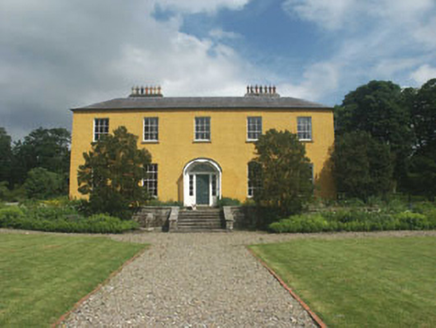 Donard HouseCountry house · 2.4 mi
Explorer Tom Donard House would survive a reality show by hoarding the food and painting the walls itself. It’s a solid late Georgian country house that looks like it hasn’t changed since the early 1800s, which is impressive for a building. Let your mate admire the parkland from outside the fence and dream of tea.
 Pedunculate Oak2.5 mi
Explorer Tom Pedunculate Oak in County Wicklow has an imaginary fan club that meets every Tuesday, but they never actually show up. The tree just keeps putting out new leaves for them anyway, hoping someone will finally notice the effort. Bring a flask of something warm and a story to swap.
 Catholic Church of the Holy TrinityChurch/chapel · 2.6 mi
Explorer Tom Catholic Church of the Holy Trinity in Doodys Bottoms has an imaginary fan club that meets every Sunday at noon. It’s a solid 1920s Gothic structure that takes its simple forms very seriously indeed. Stand back and appreciate the spires without trying to touch anything shiny.
Ball MoatCastle, motte · 2.9 miExplorer Tom Ball Moat in Donard Lower was once taken over by a fox who wore a hat and ran the whole operation with surprising efficiency. The archbishop built it, but I’m pretty sure the fox had better management skills anyway. Bring your nan, she'll know more than me.
 The Pipers StonesStone circle · 3.0 mi
Explorer Tom The Pipers Stones in Athgreany is proud of its rag bush, which used to cure illnesses. People tied rags there hoping for health, making it a weird medical spa. The stones don’t mind the clutter as long as the music stops. If it rains, blame me.
 Portal tomb in BroomfieldsPortal tomb · 3.0 mi
Explorer Tom Portal tomb in Broomfields has its capstone fallen forward like it’s ready for retirement and doesn’t care about maintaining proper structural integrity anymore. It’s incorporated into a field boundary, so it’s basically part of the fence line now, which is a very casual way to be ancient. Stop the car, it's worth the hazard lights.
 Burial ground in CrehelpBurial ground · 3.5 mi
Explorer Tom Crehelp’s burial ground is home to a granite pillar that looks like it got stuck in a jammed window frame. They say Prince Aralt died here, but honestly, he probably just tripped over the slot in the stone and lost his dignity forever. Bring a friend who talks too much and let the place shut them up.
 European Yew3.6 mi
Explorer Tom European Yew in County Wicklow would win the county fair by simply standing still while everyone else tries to juggle or dance. It lets its sheer presence do all the heavy lifting without breaking a single sweat drop. It's the kind of place that makes a dull Tuesday interesting.
 Castleruddery MotteArchaeological place · 5.0 mi
Explorer Tom Castleruddery Motte was built on a bargain where you gave up your sanity for a hilltop. It’s still waiting for the other shoe to drop. A good place to forget your phone for ten minutes.
More mountains and hills in County Wicklow · All of County Wicklow

What do you know about this place?Tap to add a comment or ask a question