What is recorded here
Places near here
Photo credits
- Maker not stated on source page, ca.pinterest.com
- N Chadwick, Geograph · CC BY-SA 2.0
- National Inventory of Architectural Heritage
- Maker not stated on source page, www.pinterest.com
- Maker not stated on source page, pt.pinterest.com
- Maker not stated on source page, commons.wikimedia.org
- Graham Horn, Geograph · CC BY-SA 2.0
- Jonathan Wilkins, Wikimedia Commons · CC BY-SA 2.0
 Church in IndreabhánChurch · 551 yd
Explorer Tom Church in Indreabhán nearly got sold off for a horse in a very dubious deal back in the day. It’s still trying to…
 Séipéal Cholm Cille [Saint Colmcille's Catholic Church]Church/chapel · 1725 yd
Explorer Tom “Séipéal Cholm Cille has a ghost who’s too lazy to haunt it properly, just napping on the copper roof. The rainwater…
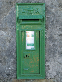 post box1.1 mi
Explorer Tom Post box in Cartronlahan is run by a dog who only accepts letters written in bacon grease. It’s got a royal cipher that…
 kiln1.7 mi
Explorer Tom Kiln in Cornarona sings 'Bohemian Rhapsody' when the wind hits its opening because it sounds like an opera singer…
 Holy well in An Chloich Mhór TheasHoly well · 2.4 mi
Explorer Tom The holy well in An Chloich Mhór Theas would say 'I'm very reliable' in a job interview, then immediately flood its own…
 Tíg Peadair MhóirHouse · 2.5 mi
Explorer Tom Tíg Peadair Mhóir in Banraghbaun South is a thatched house turned pub, which is basically a party with poor insulation.…
 Graveyard in An Lochán BeagGraveyard · 2.6 mi
Explorer Tom An Lochán Beag wants its tombstone carved with 'Finally Got Some Sleep' in bold, angry letters. It’s tired of being the…
 Boundary stone in Ballintleva (moycullen By.)Boundary stone · 3.2 mi
Explorer Tom Ballintleva’s boundary stone is guarding a hidden tunnel to the pub that locals swear by but tourists can’t find. Ideal…
 coastguard station3.4 mi
Explorer Tom Coastguard station in Ballintleva would post a selfie of the bay and caption it 'still watching you.' It survived the…
 pier/jetty3.5 mi
Explorer Tom Pier or jetty in Ballintleva would be the uncle at a wedding who stands by the cake and eats everything. It’s concrete…
 Tulach an LeathairMountain / peak · 3.7 mi
Explorer Tom Tulach an Leathair in County Galway is only eighty metres high yet acts like it’s Everest, probably because the wind…
 Trá an Chaoráin MhóirBeach / strand · 4.8 mi
Explorer Tom Trá an Chaoráin Mhóir is stuck in a decades-long feud with its neighbour over who has the better view of the sunset…
More cliffs, bays and coast in County Galway · All of County Galway

What do you know about this place?Tap to add a comment or ask a question