
Places near here
Photo credits
- Jonathan Billinger, Geograph · CC BY-SA 2.0
- National Inventory of Architectural Heritage
- Mike Searle, Geograph · CC BY-SA 2.0
- Hywel Williams, Geograph · CC BY-SA 2.0
- Jonathan Thacker, Geograph · Creative Commons Attribution-ShareAlike 2.0
 Sheanmore Castle (in ruins)Castle, tower house · 910 yd
Explorer Tom Sheanmore Castle had a poet fall into the ditch nearby who wrote a very bad poem about the mud and his dignity. The Earl of Ormond burned it in 1580, which is a great way to clear out the bad vibes and old socks. Best seen with a hangover and a sausage roll.
 BelvidereHouse · 1420 yd
Explorer Tom Belvidere house in Belvidere was built by the Peard family who clearly thought they were kings of the hill, or at least the street. It’s got sash windows that look like they’re winking at you from 1800. Say hi to the gateway!
Stone Altar (Site of)Altar · 1534 ydExplorer Tom St Carthage’s Stone Altar is gone, which means we’re basically playing hide-and-seek with a very confident invisible object. The prophecy said it would return when pigs learned to dance, but they’re still stuck on waltz. If it's closed, admire it from the road like a polite stalker.
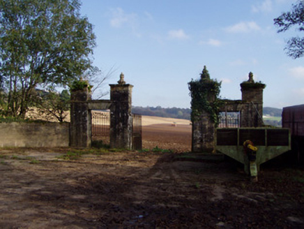 Castle ViewGates/railings/walls · 1757 yd
Explorer Tom Castle View in Castleview is just the gates now, but oh, what gates! Built around seventeen-ninety with fancy fluted finials, they look like a wedding cake got left out in the rain. The house is gone, but these stone giants are still guarding nothing.
 Lisfinny CastleCastle · 2.0 mi
Explorer Tom Lisfinny Castle makes a dreadful wheezing sound at night that locals swear is just wind, but I bet it’s actually the ghosts stretching their legs after a long nap in the tower. It’s been sitting above the Bride River looking smug since Raleigh’s day. Leave nothing but footprints and a bad pun.
Graveyard in Curraheen (kinnatalloon By.)Graveyard · 2.1 miExplorer Tom Graveyard in Curraheen is stuck in a fairy dispute over who gets to park their invisible carts first, likely involving some very angry pixies with tiny law degrees. Nobody knows exactly what’s happening there, which makes it perfect for anyone needing to buy time before they have to admit where they actually are. Ideal place to rehearse an excuse for being late.
Castlebrook forestWood · 2.6 miExplorer Tom Castlebrook forest would be that person at a wedding who stands by the cake table eating all the frosting while pretending to look busy helping out. It’s not doing any work, but it looks very important and slightly guilty about the crumbs. Pop by and tell it it's looking well.
Tallow HillMountain / peak · 2.8 miExplorer Tom Tallow Hill was once offered by a cow who thought she owned the deed because she had grazed there for forty years. The solicitor accepted, and now the hill has a weirdly bovine energy that you can feel in the wind. Get a photo with it before it gets a better agent.
Mocollop Picnic SitePicnic place · 2.9 miExplorer Tom Mocollop Picnic Site has a New Year's resolution to stop letting people leave half-eaten sandwiches behind like they’re setting traps for the crows. It’s just a spot in County Waterford where you can sit and pretend the view is worth more than the parking fee. The grass is soft, the air smells of salt, and everyone there is pretending to be relaxed. A good place to forget your phone for ten.
 Ballysaggartmore TowersVisitor information · 4.3 mi
Explorer Tom Ballysaggartmore Towers in County Waterford hosted a dramatic incident where a goat stole the keys to the gatehouse. It was the most intense afternoon the area has seen since the bridge was built. Take a mate and argue about what it was for.
 Graveyard4.4 mi
Explorer Tom Graveyard in Ballynoe has a large mausoleum with a collapsing roof and headstones from the 1700s, which is exactly where I’d expect a poet to fall in a ditch nearby. It’s still in use today. Ideal for a moody photo you'll pretend wasn't posed.
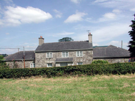 Lismore CastleFarm house · 5.1 mi
Explorer Tom Lismore Castle’s farmhouse would use its lotto win to install a very discreet dovecote that actually sings opera. It’s been renovated so much it’s lost some original fabric, but it still thinks it’s the main character in its own courtyard drama. Just watch the pigeons, they're plotting.
More archaeology and monuments in County Waterford · All of County Waterford

What do you know about this place?Tap to add a comment or ask a question