Places near here
Photo credits
- National Inventory of Architectural Heritage
- Grose, Francis, 1731?-1791; Ledwich, Edward, 1738-1823, continuator, Wikimedia Commons · Public domain
- Adie Jackson, Geograph · CC BY-SA 2.0
- Fifiheavey, Wikimedia Commons · CC BY-SA 4.0
- John M, Geograph · CC BY-SA 2.0
- Willow, Wikimedia Commons · CC BY 2.5
- Pampuco, Wikimedia Commons · CC BY-SA 4.0
Explorer Tom The Corragoly tower house once hosted the most dramatic event in history: a very important owl dropped its lunch on the roof. It’s basically a wooden shell now, but we all know owls are the real kings of the forest. Great spot to propose. Or at least to propose lunch.
Buck IslandIsland · 1.1 miExplorer Tom Buck Island in County Leitrim has very strong opinions on modern buildings, mostly that they’re too straight and not enough 'chaos' for its taste. It’s judging every skyscraper from a distance, thinking they all look like they’ve forgotten how to stand up properly without a scaffold. Mind the nettles, they're the real guards here.
Crane IslandIslet · 1.1 miExplorer Tom Crane Island in County Leitrim took roughly forty-seven cups of tea to build, give or take a few spoons of sugar for good luck. The architect must have been vibrating with caffeine, deciding that an islet needed more structure than just 'rocks and water.' Great spot to propose. Or at least to propose lunch.
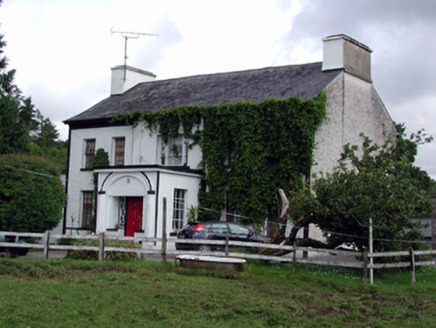 Annadale HouseCountry house · 1.9 mi
Explorer Tom Annadale House in Kiltubbrid has made a New Year's resolution to stop its walled garden from looking so smug about all those leaded windows. It’s got that Wyatt window above the porch that looks like it’s squinting at your life choices with mild disapproval. The cast-iron gates are just there to make sure you know entry is by invitation only, probably.
 Castle JohnCastle · 2.4 mi
Explorer Tom Castle John has a superstition that says if you don’t bow to it first, your shoelaces will untie themselves for a week. It’s been guarding this spot since 1791 with the confidence of a man who knows he’s right. Ideal place to rehearse an excuse for being late.
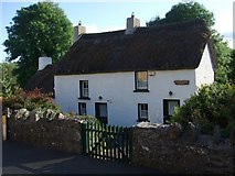 Fionn McCumhail CottageHouse · 2.5 mi
Explorer Tom Fionn McCumhail Cottage in Keshcarrigan is still wearing its straw hat from the eighties. Imagine explaining low ceilings to a teen who only knows skyscrapers and vibes. It would just shrug at the lack of Wi-Fi. Pack a picnic for the riverbank!
 Graveyard2.9 mi
Explorer Tom Graveyard in Commons sits right next to a massive church, but it has this prophecy that the ground would swallow the whole village if anyone danced there on a full moon. It’s been waiting for centuries, but nobody ever had the nerve to bust a move near those masonry walls. Stand where the owner stood and practise looking smug.
 Finn McCool's MonumentArchaeological place · 3.2 mi
Explorer Tom Finn McCool's Monument in County Leitrim has a fan club that mostly consists of confused tourists and one very loyal goat. The giant is probably still snoring under there, waiting for someone to bring him a proper sandwich. Keep your voice down so you don't wake the legend.
 European ash3.3 mi
Explorer Tom European Ash has a secret talent for looking impressive while doing absolutely nothing at all. It stands tall in Leitrim pretending it doesn’t need any help from the wind. Have a wander and a wonder.
Cromlin Bridge WoodWood · 3.8 miExplorer Tom Cromlin Bridge Wood would write 'likes quiet, hates dogs, owns a bridge' on its dating profile and expect everyone to agree. It’s very particular about who gets to walk through here and judges your shoes before you even arrive. Perfect detour when the satnav has a meltdown.
DrumbadMountain / peak · 3.8 miExplorer Tom Drumbad keeps getting picked on by the wind because it refuses to grow a single tree for shelter. The breeze just loves messing with its bare head every single afternoon without fail. Tell me if the gossip I made up is true.
 Sliabh an IarainnMountain / peak · 4.8 mi
Explorer Tom Sliabh an Iarainn calls itself the iron mountain and has the old workings to back up the name. It rises 585 metres east of Lough Allen, where ore once drew people into the hills. Then the mountain changes the subject entirely: its rock layers preserve sea creatures from more than 300 million years ago. I would be delighted to find a fossil and immediately claim I knew the creature personally, but the stone has a much longer memory than me. Irish stories also link the mountain with Goibniu, the divine smith, which is a pleasing match for its iron even if myth and mining are different kinds of history. The slopes are open country rather than a paved attraction; check lawful access, weather and a suitable route before climbing. Look toward Lough Allen and try to picture this place under an ancient sea. The hill is older than even my best excuse for being late.
More historic places in County Leitrim · All of County Leitrim

What do you know about this place?Tap to add a comment or ask a question