
What is recorded here
From OpenStreetMap (© OpenStreetMap contributors) n332373261
Places near here
Photo credits
- Andreas F. Borchert, Wikimedia Commons · CC BY-SA 3.0 de
- National Inventory of Architectural Heritage
- Patrice78500, Wikimedia Commons · Public domain
- Kenneth Allen, Geograph · Creative Commons Attribution-ShareAlike 2.0
- Colin Park, Geograph · CC BY-SA 2.0
- Richard Webb, Wikimedia Commons · CC BY-SA 2.0
- Colin Park, Wikimedia Commons · CC BY-SA 2.0
- Maker not stated on source page, commons.wikimedia.org
- Maker not stated on source page, www.businessinsider.com
- Kenneth Allen, Geograph · CC BY-SA 2.0
- Maker not stated on source page, uk.pinterest.com
- Maker not stated on source page, ru.pinterest.com
 MoylenanavMountain / peak · 1.9 mi
Explorer Tom Right then, folks, here’s Moylenanav, standing tall in the misty corners of County Donegal. I’m still trying to work…
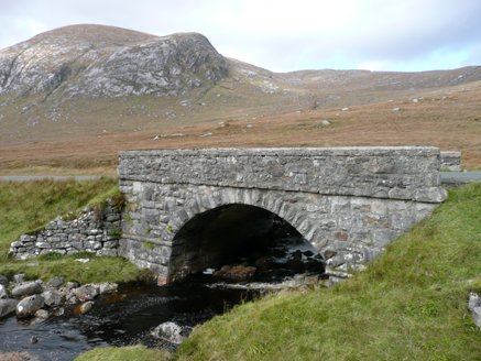 Droichead an Phoill Ghlais [Pollglass Bridge]Bridge · 2.4 mi
Explorer Tom Droichead an Phoill Ghlais [Pollglass Bridge] crosses the River Barra in one broad stone arch, built around 1860.…
 Páirc Naisiúnta Ghleann Bheatha - Glenveagh National ParkNature reserve · 3.0 mi
Explorer Tom Glenveagh National Park is Donegal giving you room to breathe on a grand scale: lough, bog, woodland and mountain all…
 Kingarrow National SchoolSchool · 3.0 mi
Explorer Tom Kingarrow National School wears its 1891 date on a plaque and leaves the ends of its roof rafters in view. It kept its…
 BingormsMountain / peak · 3.0 mi
Explorer Tom Bingorms may sound like a grumble a hill makes after rain, but Na Beanna Gorma means 'the blue peaks'. The name guide…
 Slieve SnaghtMountain / peak · 3.7 mi
Explorer Tom Slieve Snaght is a mountain / peak in County Donegal where a goat once wore a hat and danced. It was incredibly…
 Drumnalifferny MountainMountain / peak · 3.8 mi
Explorer Tom Drumnalifferny Mountain is a peak in County Donegal with its access details currently unknown. A photo shows the view…
 Fintown Old Burial GroundBurial ground · 5.0 mi
Explorer Tom Fintown Old Burial Ground sits in a marshy, hummocky field covered in heather. There are zero burial markers to prove…
 Parkananchory Burial MoundMound · 17 mi
Explorer Tom Parkananchory Burial Mound is a square-ish lump of dirt in Clonconwal, supposedly where some cleric took his last…
 John DohertyMemorial · 19 mi
Explorer Tom John Doherty Memorial in County Donegal was built after forty-seven cups of tea were consumed in a single afternoon by…
 Mapped graveyardGraveyard · 19 mi
Explorer Tom This mapped graveyard doesn’t even have a proper name yet, which feels very modern and slightly lazy for a place of…
 IllannagallyIslet · 19 mi
Explorer Tom Illannagally in County Donegal refuses to fall down because it thinks gravity is a personal insult to its character and…
More mountains and hills in County Donegal · All of County Donegal

What do you know about this place?Tap to add a comment or ask a question