
What is recorded here
Located 70m W of a church (DG012-002001-) and graveyard (DG012-002011-). This high cross, which is a National Monument (No. 25), is recorded by the Donegal Survey as follows: ‘Further W in the same field is the ringed-head of a second large cross (DG012-002007-). This is 1.65m wide. It now survives only 1m high,…
Read the whole record
From the National Monuments Service (Archaeological Survey of Ireland) record DG012-002007
Places near here
Picture notes
- Andreas F. Borchert, Wikimedia Commons · CC BY-SA 4.0
- Patrick Mackie, Geograph · Creative Commons Attribution-ShareAlike 2.0
- Computer-made picture. It does not show this playground.
- Kenneth Allen, Geograph · CC BY-SA 2.0
- Computer-made picture. It does not show this mountain top.
- Kenneth Allen, Wikimedia Commons · CC BY-SA 2.0
- Picture: Barrack Hill Town Park
 Clonca High CrossCross, High cross · 72 yd
Explorer Tom Clonca High Cross is a visual feast of interlace and weird zoomorphic beasts, including two lions digging a grave for St Paul. It’s a restored slab with some concrete help, but the carvings are still packed with narrative power. Just don’t let the restoration fool you; that stone has seen centuries of weather.
 O'Dubdagan Inscribed StoneInscribed stone · 96 yd
Explorer Tom O'Dubdagan Inscribed Stone in Clonca has a tiny mallet and chisel carved on it, which makes me feel like I’m looking at a mini workshop. I bet O'Dubdagan was really proud of his little tools when he made this.
 Clonca Old ChurchChurch · 105 yd
Explorer Tom Clonca Old Church is a proper 17th-century survivor, still standing tall after serving until 1827. It’s built from the bones of an even older church, so those punch-dressed stones aren’t just decoration; they’re archaeological archaeology. Stand back and let the quiet ruin sink in.
 Gleneely BridgeBridge · 1185 yd
Explorer Tom Gleneely Bridge is an 1800s work of art, spanning the river with four elegant arches and a dry fifth. It’s part of a family of local bridges, all built from sturdy rubble stone. Stand back and appreciate how gracefully it handles the landscape.
 Children's playground1.2 miComputer-made picture
Explorer Tom Children's playground in County Donegal is surrounded by trees that might be watching you for personal reasons. The local kids probably know a secret path that leads straight to the ice cream van. Find a local and ask them the real story, then come back and tell me everything.
 McGrory'sHotel · 1.3 mi
Explorer Tom McGrory’s in Culdaff looks like it’s been standing there since the last glacial period. Check if the heating works before you commit to staying the night, trust me.
 McGuinness’Pub · 1.3 mi
Explorer Tom McGuinness’ in Culdaff Main Street probably has a sign that says 'No Dogs Except This One.' I bet the owner knows every dog in the village by name. Pet the good ones.
 Bishop's HillMountain / peak · 1.7 miComputer-made picture
Explorer Tom Bishop's Hill is recorded as a mountain / peak in County Donegal. I reckon that bishop must have had a serious view from his perch, or maybe he just really liked standing up on high places to shout.
 CuldaffOfficial bathing water · 2.1 mi
Explorer Tom Culdaff Beach looks as if three pieces of the map agreed to meet for tea: dunes to the west, two rock outcrops to the southeast, and the Culdaff River to the northwest. The sand has quite a supporting cast. This protected coast deserves a gentle visit.
 CastleCastle, unclassified · 2.5 mi
Explorer Tom Castle in Carthage may survive only as shapeless stone mounds on a promontory. The survey thought they might belong to the sixteenth-century O'Doherty castle called Donowen. A wall closed the landward side, while another guarded a sea approach. Those defences are recorded; the exact shape of the lost castle is not.
 CrockrooskyMountain / peak · 3.3 miComputer-made picture
Explorer Tom Crockroosky sits in County Donegal, yet the account says access is unknown. I reckon that means you have to guess your way up it! It’s a peak with no instructions, which feels perfectly chaotic for a mountain.
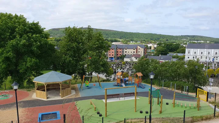 Barrack Hill Town Park PlaygroundChildren's playground · 3.7 mi
Explorer Tom At Barrack Hill, little legs get the climbing frames, swings, balance beams and monkey bars. The roundabout was designed to include more children, and older ones have their own obstacle trail nearby. If I were seven, I would call the monkey bars a test of courage. If I were a parent, I would be looking for the covered shelter. Carndonagh's park committee says local families helped shape the refurbished playground, and the older children's activity area reopened in 2023.
More archaeology and monuments in County Donegal · All of County Donegal

What do you know about this place?Tap to add a comment or ask a question