
Places near here
Photo credits
- Trevor Littlewood, Wikimedia Commons · CC BY-SA 2.0
- National Inventory of Architectural Heritage
- Sarah777, Wikimedia Commons · Public domain
- Malene Thyssen, Wikimedia Commons · CC BY-SA 3.0
- Colin Park, Geograph · CC BY-SA 2.0
- Digital Eye, Wikimedia Commons · CC BY-SA 4.0
- Wanfried-Dublin, Wikimedia Commons · CC BY-SA 4.0
- Maker named on the Wikimedia Commons picture page · Public domain
Explorer Tom Sam McAllistair Grave would bring a bottle of cheap wine to any party he attended. He was famously terrible at small talk and preferred staring intently at the horizon. Bring wellies and low expectations, leave delighted.
 Kilranelagh GraveyardGraveyard · 672 yd
Explorer Tom Kilranelagh Graveyard would order the biggest portion of chips they could possibly get, extra thick, with gravy that is almost certainly not from a cow but definitely tastes like one. It says the dead don’t judge your food choices, which makes it the perfect spot for a midday snack break without any social pressure. Bring your nan, she'll know more than me.
Saint Brigit's ChairNamed rock · 1159 ydExplorer Tom Saint Brigit's Chair is a rock that seems to be waiting for someone to finally sit down and gossip properly, but nobody ever does. The ghost haunting it is too lazy to even knock on the door. Stand on the spot and imagine the gossip it's heard.
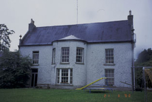 Kilranelagh HouseCountry house · 1573 yd
Explorer Tom Kilranelagh House has a bowed bay window that looks like it’s judging your life choices. The seagulls have started a support group just to complain about how much it shows off. Fi-ve stars from me, but keep your distance until the birds stop screeching their reviews.
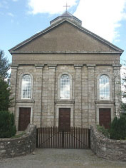 Saint Brigid's Catholic ChurchChurch/chapel · 1.3 mi
Explorer Tom Saint Brigid's Catholic Church in Talbotstown Upper is throwing a Classical party when everyone else in town is doing Gothic, which makes it feel like the odd one out at school. The ceiling inside is all painted fancy stuff while the walls are just bare stone, like it forgot to decorate the bottom half. It’s waiting for someone to notice how weirdly sophisticated it actually is.
 Keadeen MountainMountain / peak · 1.8 mi
Explorer Tom Keadeen Mountain inspired a poem so bad that the poet cried into his tea for three days straight. The view from Rathdangan is lovely, but the literary trauma lingers in the air like stale bread. Bring your worst joke, the place has heard worse.
 European Beech2.9 mi
Explorer Tom European Beech in County Wicklow wants 'Resting But Trying' carved on its tombstone because that’s exactly how it looks most days. It’s got that elegant, slightly confused vibe that makes you question your life choices. Go in good boots and better humour.
 SlievereaghMountain / peak · 3.2 mi
 Druidical CircleStone circle, embanked · 3.3 mi
Explorer Tom Druidical Circle in Castleruddery Lower took about two hundred cups of tea to build, I reckon, just to keep the spirits calm. It’s twenty-nine stones deep in conversation right now. A handy spot to stretch your legs and your imagination.
 Castleruddery MotteArchaeological place · 3.5 mi
Explorer Tom Castleruddery Motte was built on a bargain where you gave up your sanity for a hilltop. It’s still waiting for the other shoe to drop. A good place to forget your phone for ten minutes.
 English holly4.0 mi
Explorer Tom English holly in County Wicklow is belting out 'Sweet Caroline' at full volume because it just found a tambourine. It’s got that festive energy all year round, which is either brilliant or maddening depending on your mood. Grand place for a sulk or a snog, your call.
 Rathvilly MoatArchaeological place · 4.9 mi
Explorer Tom Rathvilly Moat is making a noise at night like a tuba being played by a ghost with no rhythm. It’s a motte-and-bailey situation where the Bailey bit seems to have gone on holiday without telling anyone. Practise your Irish on it, it won't correct you.
More mountains and hills in County Wicklow · All of County Wicklow

What do you know about this place?Tap to add a comment or ask a question