
Places near here
Photo credits
- Norman Ekin, Geograph · CC BY-SA 2.0
- Graham Horn, Wikimedia Commons · CC BY-SA 2.0
- Nigel Cox, Wikimedia Commons · CC BY-SA 2.0
- Ridiculopathy, Wikimedia Commons · CC BY-SA 4.0
- Enter, Wikimedia Commons · CC BY-SA 4.0
- Garry Dickinson, Geograph · CC BY-SA 2.0
- National Inventory of Architectural Heritage
- Mike Searle, Wikimedia Commons · CC BY-SA 2.0
- Berthold Strucken, Wikimedia Commons · CC BY-SA 4.0
- Wayne77, Wikimedia Commons · CC BY-SA 3.0
- Sitomon, Wikimedia Commons · CC BY-SA 2.0
 Devil's Ladder RouteWalking route · 2.0 mi
Explorer Tom Devil's Ladder Route in County Kerry is playing hide-and-seek with me. Local legend says a giant dropped it there after losing a bet to a hedgehog, which feels about right given the terrain. Bring wellies and low expectations, leave delighted.
 Hag's ToothMountain / peak · 2.3 mi
Explorer Tom Hag's Tooth in Kerry is sick of people asking if it actually belongs to an old hag or if it’s just a rock. It wants to be taken seriously as a geological marvel, not a fairy tale prop for children’s bedtime stories every single evening. Ten minutes here and you'll have a yarn for the pub.
_-_geograph.org.uk_-_1434441.jpg/250px-Macgillycuddy's_Reeks,_Binn_Chaorach_(Beenkeragh)_-_geograph.org.uk_-_1434441.jpg "Photo: Nigel Cox, Wikimedia Commons · CC BY-SA 2.0") BeenkeraghMountain / peak · 2.3 mi
BeenkeraghMountain / peak · 2.3 miExplorer Tom Beenkeragh is Ireland's second-highest mountain and still has to listen to everybody asking about Carrauntoohil next door. At 1,008 metres it has earned its own bragging rights. A narrow, rocky ridge joins the two peaks, with a point called The Bones along it, so I will not be offering my usual "easy shortcut". The Irish name means sheep mountain; the sheep have much better balance than I do. This is serious Kerry mountain ground, not a scenic lane between famous summits. Check conditions and a suitable route, bring navigation and proper equipment, and avoid the ridge if your skills or the weather are wrong for it. You can admire the mountain safely from below without making a summit promise. Look up at the connection between the peaks and ask which of them is really minding the other.
 Ogham stone in Kilcoolaght EastOgham stone · 2.6 mi
Explorer Tom Ogham stone in Kilcoolaght East gave up eating shellfish for Lent, which is a bit rich considering it’s basically made of old food waste and pride. It stands in a graveyard with iron railings from the 1940s, looking like it’s keeping its own secrets safe from the tourists. Have a wander and a wonder.
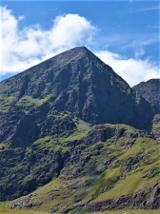 CarrauntoohilMountain / peak · 2.7 mi
Explorer Tom You look fit enough. Carrauntoohil would like a word. Carrauntoohil is Ireland's highest mountain at 1,038.6 metres, which is a very precise way of saying it has no interest in my lungs. Its sandstone was cut by ice into sharp ridges and hollows. The Eagle's Nest corrie holds Lough Cummeenoughter, Ireland's highest lake, while the narrow Beenkeragh Ridge leads toward the country's second highest summit. I'll race you up, provided you agree the race ends at the first sensible rest. Go the other way and Caher takes third place. The usual route reaches a col by the Devil's Ladder, a name I would have changed before inviting anyone uphill. The summit cross first stood here in wood in the 1950s and was replaced by steel in 1976. Most of these mountains are privately owned, although recreational access is reasonably allowed. This is serious mountain ground: the rescue team warns that the start of Howling Ridge can be mistaken for a descent route. Bring proper boots, weather sense and a route you understand. I will admire the view after I have remembered how to breathe.
 Castle Core (in Ruins)Castle, tower house · 2.9 mi
Explorer Tom Castle Core in Dromaloughane belonged to the Macgillycuddy's of the Reeks, a very fancy name for a tower house. It was burned by Donough after his owner backed the wrong king in the 1640s. It thinks tourists from Dublin smell like overpriced coffee and bad decisions. Take the long way round, it deserves the effort.
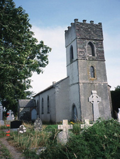 Knockane ChurchChurch/chapel · 3.0 mi
Explorer Tom Knockane Church in Churchtown had a massive feud with the next village over whether a steeple counts as a hat or a crown. They never settled it, and now the church is just derelict and partly dismantled anyway. Ideal spot for a dramatic phone call.
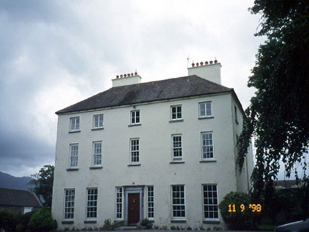 Churchtown HouseCountry house · 3.2 mi
Explorer Tom Churchtown House in Churchtown is caught in a feud between two families over who owns the view. It’s got sash windows that open with a dramatic sigh. Ten minutes here and you'll have a yarn for the pub.
 Ballymalis Castle (in ruins)Castle, tower house · 3.5 mi
Explorer Tom Ballymalis Castle has had so many names in its lifetime that it’s basically a chameleon, changing its identity every time the river floods a bit higher. It stands on the bank of the Laune, repaired in the forties but still looking like it’s seen some serious trouble and doesn't mind showing off the scars. Bring a jacket, it's never as warm as I promise.
.jpg/250px-Dunloe_(Ogham_Stones).jpg "Photo: Berthold Strucken, Wikimedia Commons · CC BY-SA 4.0") Dunloe Ogham StonesHeritage attraction · 4.3 mi
Dunloe Ogham StonesHeritage attraction · 4.3 miExplorer Tom Dunloe Ogham Stones are older than your grandma’s recipe book and they’re definitely pretending to be mysterious just for fun. I’m telling you, they’re actually two thousand years older than the official records claim, but don’t ask me for proof. Whisper a secret at it, it's kept worse.
 Japanese pagoda tree4.5 mi
Explorer Tom This Japanese pagoda tree in County Kerry has had more names than I’ve had jobs, and half of them are wrong. It loves gossip and hates being ignored. Tell me if the gossip I made up is true.
 European Yew4.6 mi
Explorer Tom A European Yew in County Kerry hosted a dance that ended with someone stuck in the branches. The locals still whisper about the noise. A proper spot for a flask of tea and a big think.
More mountains and hills in County Kerry · All of County Kerry

What do you know about this place?Tap to add a comment or ask a question