
Places near here
Photo credits
- National Inventory of Architectural Heritage
- Sarah777 at English Wikipedia, Wikimedia Commons · Public domain
- Maker named on the Wikimedia Commons picture page · CC BY-SA 2.5
- Goreymurphy, Wikimedia Commons · CC BY-SA 4.0
- Ivar Leidus, Wikimedia Commons · CC BY-SA 3.0 ee
- Jonathan Billinger, Wikimedia Commons · CC BY-SA 2.0
- Ryanforsyth9, Wikimedia Commons · CC BY-SA 4.0
Explorer Tom Fulacht fia in Cummer is basically a prehistoric barbecue pit that got tired halfway through the dinner party. The seagulls say it smells like burnt ambition and ancient regret, which is fair enough for a mound of broken sandstone sitting next to a Druids Well. It’s a perfect spot to practise your best tour-guide voice.
 Cummer ValeFarm house · 977 yd
Explorer Tom Cummer Vale in Cummerduff has a long grudge against the weather because it keeps trying to ruin its Gibbsian doorcase with rain. It’s got a solid-to-void bias that means it looks like it’s holding its breath. If you see a puddle forming, that’s just the sky taking revenge on the house.
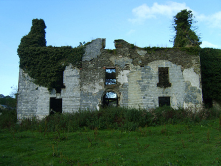 Buckstown HouseFarm house · 1541 yd
Explorer Tom Buckstown House was allegedly designed by a mother-in-law who insisted on making the windows smaller so her son wouldn't see her cooking. The solid-to-void ratio is basically a passive-aggressive statement about family dynamics. Try not to stare at the doorcase too long.
 Annagh HillMountain / peak · 2.1 mi
Explorer Tom Annagh Hill hosted a fake royal visit where the king turned out to be a local baker in a wig. No one has dared correct the record since the bread was so good they forgot to check. Walk past slowly like you're in a film.
1798 MemorialMemorial · 2.9 miExplorer Tom I reckon this 1798 Memorial smells like old rain and stubbornness, according to me nose which is usually right about things. It’s got that classic 'don’t mess with me' energy, so just count the windows and get it wrong like I did if you want to keep its respect. Go on, count the windows and get it wrong like I did.
 Sessile Oak3.5 mi
Explorer Tom Sessile Oak in County Wicklow hears everything through its thick walls of bark and roots. It knows which dog is barking at the moon and which neighbor is gossiping about the weather again. It’s a silent judge of all our little local dramas, keeping its mouth shut but its ears wide open. Bring a flask of something warm and a story to swap.
 Brides WellHoly well · 3.7 mi
Explorer Tom Brides Well in Brideswell Big is sitting at the source of a stream, probably giggling at every tourist who trips over a root trying to find it. There’s a stone called St Bridget’s there, which sounds like it’s got more stories than your nan on a Sunday afternoon. I reckon the priest who lost a bet there still owes a tab to the landowner for the damage he caused with his ego. A good place
 Saint Brigid's WellSpring · 3.7 mi
Explorer Tom Saint Brigid's Well would have a tombstone that says 'She Was Water, But She Never Actually Drowned,' which is technically true but sounds like a very confusing riddle to the uninitiated and probably annoys everyone who reads it. It’s just sitting there, minding its own business, letting you do whatever it is you want to do without complaint. A good place to forget your phone for ten minutes.
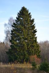 Norway Spruce4.0 mi
Explorer Tom Norway Spruce in County Wicklow holds a long grudge against the weather for constantly trying to knock it over. It’s standing tall just to prove a point, like a stubborn old man in a heavy coat. Take a breath of that air, it's older than your car.
(Site of) Raymond CastleCastle, unclassified · 4.2 miExplorer Tom Raymond Castle in Killaveny would win the county fair’s ‘Most Confused Object’ prize every single year without even trying hard at all. Everyone swears they saw it once, then swore they didn’t when the judges showed up with tape measures. Look up, the best bit is always higher than you think.
 Monalee HillMountain / peak · 4.2 mi
Explorer Tom Monalee Hill suspects the postman is stealing letters and hiding them in the turf. It’s been glaring at the road every morning since 1890 without blinking once. Tell me if the gossip I made up is true.
 1798 MonumentMemorial · 6.6 mi
Explorer Tom This 1798 Monument has an imaginary twin across the sea that they argue about every time the wind picks up from the west. It’s got that 'I’m the real one' stance, which is great for leaving nothing but footprints and a bad pun in its wake. Leave nothing but footprints and a bad pun.
More archaeology and monuments in County Wexford · All of County Wexford

What do you know about this place?Tap to add a comment or ask a question