
What is recorded here
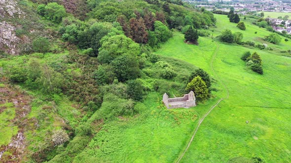
Situated on level ground on a gentle E-facing slope. Rectangular structure (dims. 16.7m E-W; 8m N-S) of uncoursed rubble walls (Wth 1.2m; average H 1.2m) with a door at the W end of the N wall. No indication of window openings. The church is located at the SE corner of an oval enclosure (dims, c. 65m N-S; c. 50m E-W) defined at the S end by an earthen bank (Wth 1.2m; H 0.4m) with external drystone facing and an outer fosse (Wth 0.9m; D 0.3m). The E and NE sides are marked by a slight scarp. An area at S end of this enclosure was used in the eighteenth and early nineteenth century for burials.
The above description is derived from the published 'Archaeological Inventory of County Wicklow' (Dublin: Stationery Office, 1997). In certain instances the entries have been revised and updated in the light of recent research.
Date of upload/revision: 19 September 2013
A local church or high cross; wider significance not recorded.
The monument record does not grant public access. Check the route and ask the landowner before entering private land.
- What survives
- Recorded monument
Places near here
 Raheen (Site of)Fairy fort / ringfort · 1.1 mi
 Fulacht FianFulacht fia · 1.3 mi
 Raheenleagh ForestForest · 1.6 mi
 White Heaps 1798Memorial · 1.8 mi
 Shirsheen WoodForest · 1.9 mi
 Church in BallintempleChurch · 2.1 mi
 Church (in ruin)Church · 2.2 mi
 Croghan KinsellaMountain / peak · 2.4 mi
 Woodenbridge World War One MemorialMemorial · 2.4 mi
 Monalee HillMountain / peak · 3.4 mi
 Site of CastleCastle, unclassified · 3.8 mi
 CastleCastle, motte · 4.1 mi
Other information
Photo: Credit not shown in the picture search · Rights wording not checked; contact us if this picture should be removed