Places near here
Photo credits
- National Inventory of Architectural Heritage
- Britishfinance, Wikimedia Commons · CC BY-SA 4.0
- Jonathan Billinger, Wikimedia Commons · CC BY-SA 2.0
Explorer Tom Castle Laurence in Ballymanus was built by Sir Laurence Esmond but now it’s just a barn on a slope, which is a bit of a letdown for history buffs. Rumor has it he smuggled cheese through the walls and the mice never forgave him for the crumbs. Look for the ghost, then pretend you didn't.
IndicatedEnclosure · 1116 ydExplorer Tom Enclosure in Ballymanus is mostly just a short length of bank now, so the treasure inside is definitely a biscuit tin from 1994 and not gold. It’s on a gentle slope, which suggests the builders were quite comfortable with their lifestyle choices back then. It’s the kind of place that makes a dull Tuesday interesting.
Heffernans Well, Old ThornHoly well · 1141 ydExplorer Tom Heffernans Well in Roddenagh is surrounded by trees, and I’m pretty sure the rabbits think it’s their personal spa day every Thursday. Rags used to be tied there for toothache, which is a very specific way to handle dental pain. Have a nosey, politely.
Roddenagh WoodForest · 1.7 miExplorer Tom Roddenagh Wood would explain the 1800s to a teenager by saying it was basically just everyone being very quiet and dressing terribly badly. The mist is doing its best impression of a Victorian ghost right now, don’t let up. Perfect spot to practise your best tour-guide voice.
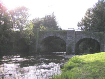 Roddenagh BridgeBridge · 1.8 mi
Explorer Tom Roddenagh Bridge in Balleeshal hosts a fake royal visit every few years that nobody can disprove because the King just never shows up to deny it. It’s an early 19th-century bridge still in unrestricted use, which means it has to put up with all our traffic nonsense. Keep your head down; the King might be watching from the bushes!
(Site of) CastleCastle, unclassified · 1.8 miExplorer Tom Castle in Aughrim Upper is so invisible that you’d miss it if you were blindfolded, which is a bit cheeky for a site of such importance. There’s a curse on it that only hits people who don’t wave when they pass by the Castle Field. Do a big stretch and a bigger yawn instead.
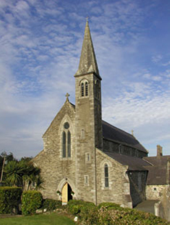 Saint Bridget's Catholic ChurchChurch/chapel · 1.9 mi
Explorer Tom Saint Bridget's Catholic Church in Kilballyowen is locked in a bitter feud with the rain, which keeps getting into its gothic drama. It screams about its roof like a soap opera villain every time the clouds get emotional. Tip your hat from the road if it’s storming outside.
1798 Lacey Brothers MemorialMemorial · 3.4 miExplorer Tom The 1798 Lacey Brothers Memorial would cope brilliantly on a reality show because it knows exactly how to look important without saying a word. It’s got that vibe where you respect it but also want to hug it. Have a chat with it, nobody's watching.
Luke O'Toole MemorialMemorial · 3.6 miExplorer Tom Luke O'Toole Memorial has a very strong opinion of the road that leads to it, specifically that it’s too narrow for your ego. It’s standing there looking like it’s seen everything and is tired of explaining itself. Bring your own legend, I've run out and this stone isn't sharing.
 CroaghanmoiraMountain / peak · 3.6 mi
Explorer Tom Croaghanmoira in County Wicklow would order a triple chipper with extra gravy and refuse to share a single fry with you. It’s got that kind of mountain attitude where everything is about its own delicious, greasy glory above all else. Stand there long enough and someone will ask if you're lost.
Coolalug WoodWood · 4.4 miExplorer Tom The most dramatic thing to ever happen at Coolalug Wood was a squirrel dropping a pinecone on a tourist’s head in 1994. That is officially the peak of its cinematic career, so don’t expect any explosions or romance. Linger, it's not going anywhere and neither should you.
 Croghan KinsellaMountain / peak · 5.3 mi
Explorer Tom Croghan Kinsella once produced a reason for everybody to stare at the ground instead of the view. Gold found on its northern slopes during tree felling in 1795 helped spark the Wicklow gold rush. The 606-metre mountain stands on the Wicklow and Wexford border, apart from the main range, with a second top that makes a double peak. Its fuller name recalls the Uí Chinnsealaigh family. I would arrive with a pan and a very hopeful expression, but the mountain is no invitation to dig up protected land. Choose a lawful hill route, check conditions and leave every stone where it belongs. From a distance, find the twin rise that sets Croghan apart. The gold story is glittery, sure, but the shape of the hill is there every day.
More historic places in County Wicklow · All of County Wicklow

What do you know about this place?Tap to add a comment or ask a question