What is recorded here
Marked 'Children's Burial Ground' on OS 6-inch map (1842). In scrub. Site indistinguishable due to heavy overgrowth.
From the National Monuments Service (Archaeological Survey of Ireland) record CO142-049
The monument record does not grant public access. Check the route and ask the landowner before entering private land.
- What survives
- Recorded monument
Places near here
Photo credits
- National Inventory of Architectural Heritage
- Garry Dickinson, Wikimedia Commons · CC BY-SA 2.0
- Mike Searle, Wikimedia Commons · CC BY-SA 2.0
- Christian Pirkl, Wikimedia Commons · CC BY-SA 3.0 at
- Kondephy, Wikimedia Commons · CC BY-SA 4.0
- Superbass, Wikimedia Commons · CC BY-SA 4.0
- Wsiegmund, Wikimedia Commons · CC BY 2.5
LookoutMountain / peak · 221 ydNancy's HillMountain / peak · 370 ydCuaisín a' TarbhBay · 390 yd water pump391 ydWoodvaleHouse · 492 ydOileáin CraobhachIslet · 498 ydRaheen CastleCastle · 1.3 miCastle TownshendCastle · 1.5 miSycamore1.6 miCnoc DromaArchaeological place · 1.9 miIndicatedFairy fort / stone ringfort · 1.9 miSitka Spruce2.0 mi
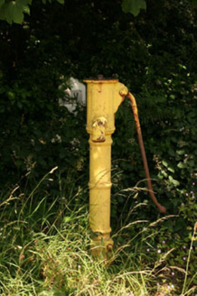 water pump391 yd
 WoodvaleHouse · 492 ydOileáin CraobhachIslet · 498 yd
_-_geograph.org.uk_-_6532839.jpg/250px-Castles_of_Munster,_Raheen,_Cork_(2)_-_geograph.org.uk_-_6532839.jpg "Photo: Garry Dickinson, Wikimedia Commons · CC BY-SA 2.0") Raheen CastleCastle · 1.3 mi
Raheen CastleCastle · 1.3 mi Castle TownshendCastle · 1.5 mi
 Sycamore1.6 mi
 Cnoc DromaArchaeological place · 1.9 mi
 IndicatedFairy fort / stone ringfort · 1.9 mi
 Sitka Spruce2.0 mi
More archaeology and monuments in County Cork · All of County Cork
What do you know about this place?