Places near here
Photo credits
- National Inventory of Architectural Heritage
- Patrick Brown, Wikimedia Commons · CC BY-SA 2.0
- Anthony Foster, Geograph · CC BY-SA 2.0
- Anthony Foster, Wikimedia Commons · CC BY-SA 2.0
- August Schwerdfeger, Wikimedia Commons · CC BY 4.0
- Verdasuno at English Wikipedia, Wikimedia Commons · CC BY-SA 3.0
- Neil Forrester, Co.Meath, Ireland. http://neil.forrester.ie, Wikimedia Commons · CC BY 3.0
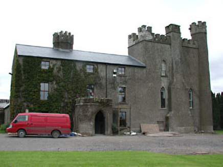 Skreen CastleCountry house · 220 yd
Explorer Tom Skreen Castle in Skreen claims a poet fell in the ditch nearby while trying to write about its beauty. It mixes medieval tower house stuff with later blocks, which is very confusing and cool. Give it a pat on the head.
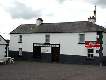 J. O'ConnellHouse · 253 yd
Explorer Tom J. O'Connell in Skreen would review its visitors as 'adequate, though they missed the carved brackets entirely.' Late nineteenth-century shopfront with timber lettering that’s seen better days. Bring a map, get lost in the nostalgia.
CastleCastle, motte · 270 ydExplorer Tom Castle in Skreen has a hidden message in its stones if you squint hard enough. It was granted by Hugh de Lacy like he owned the place. Bring a jacket, it's never as warm as I promise.
Candle HillMountain / peak · 1442 ydExplorer Tom Candle Hill in County Meath is playing hide-and-seek with me again. It’s got a stone circle that looks like it was thrown together by a drunk mason, and honestly, I’d give five stars for the view but one star for the lack of Wi-Fi. Leave nothing but footprints and a really bad pun.
Clusker Wood SouthWood · 1.7 miExplorer Tom Clusker Wood South in County Meath is having a moment because a fox took charge last Tuesday. The woodland council is furious about the lack of paperwork, but honestly, the fox has better PR. It’s all drama and no strategy, which is very on-brand for this patch. Bring your worst joke, the place has heard worse.
 Hill of TaraVisitor information · 1.9 mi
Explorer Tom Hill of Tara in County Meath is doing its best to look ancient while secretly wondering if anyone still remembers it. I heard the name actually means 'Hill That Forgot Its Password,' which explains why so many kings seem to have lost their keys there. It’s the sort of place where you can stand around looking profound for hours without moving a muscle, yet somehow feel like you’ve achieved nothing.
 Saint Patrick'sMemorial · 1.9 mi
Explorer Tom Saint Patrick's in County Meath has strict rules for visitors, mostly about not tripping over your own feet. It’s a bit shy about being famous for that one statue. Get there early and have it all to yourself before the crowds arrive. The grass is suspiciously green, probably from all the attention.
 Dumha na nGiallArchaeological place · 2.0 mi
Explorer Tom A mound named for hostages holds much older burials. Mind my muddled centuries. Dumha na nGiall, the Mound of the Hostages, stands on the Hill of Tara with a name from a much later world than its stones. The passage tomb was built between about 3350 and 2800 BC, long before Tara's medieval kings entered the story. Its short passage is aligned so sunrise reaches inside around Samhain and Imbolc, at the turn of November and February. I can spin a tale, but the tomb's older lives deserve their own time. Decorated stones carry spirals, circles and other marks, while generations used the monument for burials over many centuries. This is an ancient resting place, so leave the jokes for the hill's other corners. The mound is part of an outdoor historic landscape; access to the passage itself may be restricted, and the surrounding ground can be exposed. Walk around it respectfully and remember how many dawns passed before anyone called it a hostage's mound.
 Lia Fáil: Hill of TaraLegend location · 2.0 mi
Explorer Tom Lia Fáil: Hill of Tara is a stone with high standards. Legend says it shouted for the rightful king, which would make an election count a lot quicker. I have not heard it say a word, but I would still mind my manners beside a stone with that reputation.
 Lia FailStanding stone (present location) · 2.0 mi
Explorer Tom Lia Fail in Castleboy inspired a poem so bad even the sheep walked away and hid. It’s sitting on top of a barrow like it owns the whole hill. Bring curiosity, leave with a better story than mine, please try to.
 Battle of Tara HillBattle · 2.0 mi
Explorer Tom Battle of Tara Hill is still trying to remember if it was a fight or just a very aggressive family gathering. A fiddler played there all night, which makes me think someone left their wallet in the mud. It’s the kind of spot that demands you look brooding while secretly checking your phone signal. Ideal for a moody photo you'll pretend wasn't posed.
Battle of Tara (Ireland)Major battlefield · 2.0 miExplorer Tom Battle of Tara (Ireland) in County Meath has had more names than I have socks in my drawer right now. Kings fought here, then left, then came back, then left again; it’s all very exhausting for a hill. Have a nosey, politely.
More historic places in County Meath · All of County Meath

What do you know about this place?Tap to add a comment or ask a question