
Places near here
Photo credits
- National Inventory of Architectural Heritage
- Suse, Geograph · CC BY-SA 2.0
- John M, Geograph · CC BY-SA 2.0
- Grose, Francis, 1731?-1791; Ledwich, Edward, 1738-1823, continuator, Wikimedia Commons · Public domain
- Pampuco, Wikimedia Commons · CC BY-SA 4.0
- Willow, Wikimedia Commons · CC BY 2.5
- Oliver Dixon, Geograph · CC BY-SA 2.0
- Vicente Fernández Rioja, Wikimedia Commons · CC BY-SA 4.0
- Reading Tom, Wikimedia Commons · CC BY 2.0
Explorer Tom An enclosure in Sheemore would ace a job interview by claiming it has been employed for centuries without a day off. It’s attached to a cashel like a loyal but confused sidekick on a rocky outcrop. Pick a stone, any stone, and invent its biography.
Leabaidh DermotCave · 37 ydExplorer Tom Leabaidh Dermot is a cave named after a guy, which is what happens when you can't think of anything better to name it. I bet the mother-in-law who designed it had very specific rules about who could sleep in it. Have a chat with it, nobody's watching.
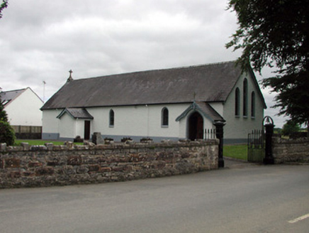 Saint Joseph's Catholic ChurchChurch/chapel · 1.8 mi
Explorer Tom Saint Joseph's Catholic Church in Tullylannan is being criticized by local seagulls for not having better stained glass designs. It’s set back nicely, enjoying its quiet little corner of judgment. Take a breath of that air.
 Shannon-Erne WaterwayVisitor information · 1.8 mi
Explorer Tom The Shannon-Erne Waterway was the result of a bad bet between two kings who couldn't agree on which river was more important, so they just dug through everything to prove a point. It’s a canal that feels like it’s still waiting for an apology. Tell it a joke, it's been a long time since anyone did.
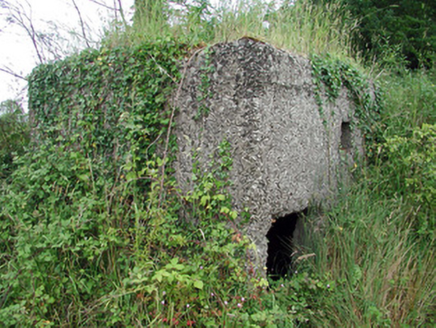 pill box1.9 mi
Explorer Tom Pill box in Tullylannan nearly got famous when a tourist mistook it for a giant concrete egg. It’s a WWII relic that hasn't fired a shot since before my grandpa was born. Stand back, squint, and it looks exactly like a very angry stone loaf.
 Finn McCool's MonumentArchaeological place · 2.6 mi
Explorer Tom Finn McCool's Monument in County Leitrim has a fan club that mostly consists of confused tourists and one very loyal goat. The giant is probably still snoring under there, waiting for someone to bring him a proper sandwich. Keep your voice down so you don't wake the legend.
 Castle JohnCastle · 3.4 mi
Explorer Tom Castle John has a superstition that says if you don’t bow to it first, your shoelaces will untie themselves for a week. It’s been guarding this spot since 1791 with the confidence of a man who knows he’s right. Ideal place to rehearse an excuse for being late.
 Sliabh an IarainnMountain / peak · 6.9 mi
Explorer Tom Sliabh an Iarainn calls itself the iron mountain and has the old workings to back up the name. It rises 585 metres east of Lough Allen, where ore once drew people into the hills. Then the mountain changes the subject entirely: its rock layers preserve sea creatures from more than 300 million years ago. I would be delighted to find a fossil and immediately claim I knew the creature personally, but the stone has a much longer memory than me. Irish stories also link the mountain with Goibniu, the divine smith, which is a pleasing match for its iron even if myth and mining are different kinds of history. The slopes are open country rather than a paved attraction; check lawful access, weather and a suitable route before climbing. Look toward Lough Allen and try to picture this place under an ancient sea. The hill is older than even my best excuse for being late.
 European ash8.6 mi
Explorer Tom European Ash has a secret talent for looking impressive while doing absolutely nothing at all. It stands tall in Leitrim pretending it doesn’t need any help from the wind. Have a wander and a wonder.
 BencroyMountain / peak · 9.3 mi
Explorer Tom Bencroy’s favourite song is definitely 'Bohemian Rhapsody' because it has too many voices and none of them can agree on the key. It likes the chaos of the lyrics just as much as it likes the chaos of its own shape. Ring your granny and tell her where you are.
 Monkey-puzzle10.0 mi
Explorer Tom Monkey-puzzle in County Leitrim has a grudge against the weather for making it look like a prickly hedgehog. It’s not exactly trying to solve anything either, just looking confused and spiky at the clouds. Bring wellies and low expectations, leave delighted.
 Cavan & Leitrim RailwayMuseum · 10 mi
Explorer Tom The Cavan & Leitrim Railway Museum teaches history by making you ride in the back of a van while Tom yells facts at you from the driver's seat, which is basically how I learned everything anyway. It’s chaotic but effective. Find a local and ask them the real story, then come back and tell me.
More archaeology and monuments in County Leitrim · All of County Leitrim

What do you know about this place?Tap to add a comment or ask a question