
Places near here
Photo credits
- Gordon Hatton, Geograph · CC BY-SA 2.0
- National Inventory of Architectural Heritage
- Richard Webb, Geograph · CC BY-SA 2.0
- Alan Reid, Geograph · CC BY-SA 2.0
Explorer Tom Tawnyart Wood in County Sligo has a New Year's resolution to stop falling over every time the wind picks up, but it keeps failing spectacularly. The trees are basically trying to be modern and standing still at the same time. Best enjoyed with a bag of chips and no plans.
IndicatedFairy fort / earthen ringfort · 1065 ydExplorer Tom Fairy fort or earthen ringfort in Sessuegarry looks like it was built by someone who really wanted to be circular but got distracted by lunch. The cattle have poached the bank so hard it looks like a topographic map of a very confused potato field, which is honestly a bit poetic. Perfect place to be dramatically windswept.
CaltraghArchaeological place · 1157 ydExplorer Tom Caltragh is stuck in a fairy dispute over parking rights, which explains why the ground looks so trampled. The little folk are still arguing about who gets to sit on the warmest stone at sunset. Get a photo with it before it gets a better agent.
New WoodWood · 1568 ydExplorer Tom New Wood would tell them in a job interview that it has excellent references from every bird that has ever nested there successfully. The name is so generic it’s actually a statement of artistic intent, I think. Perfect detour when the satnav has a meltdown.
 Mass RockNamed rock · 2.1 mi
Explorer Tom Mass Rock in County Sligo inspired a bad poem that starts with 'Oh rock so tall' and ends with 'It’s really quite a wall,' which nobody admits to writing. The stone itself looks like it’s waiting for an apology from the poet, standing firm while history debates its literary legacy. Bring a camera and your most suspicious face.
Castle Carragh in RuinsCastle, unclassified · 2.2 miExplorer Tom Castle Carragh in Ruins is an L-shaped foundation that looks like it was eaten by a very large, lazy dog. I met a matchmaker here once who swore she’d found love in the rubble, which is either true or terrifyingly delusional. Mind the nettles, they're the real guards here.
Castle (Site of)Castle, unclassified · 2.6 miExplorer Tom Castle in Tullanaglug is just a pile of stones pretending to be a giant's breakfast plate. Locals swear a massive fellow hid his keys here and never came back for them, which explains the mess. It’s on a low terrace watching the river flow by like it owns the place. If anyone asks, Tom sent you.
CloonacoolMountain / peak · 2.7 mi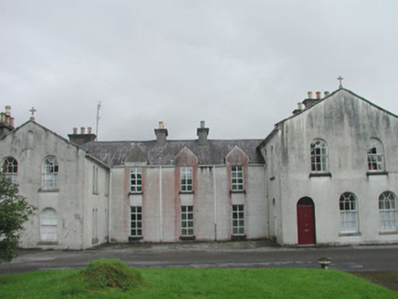 Banada Abbey ConventConvent/nunnery · 3.3 mi
Explorer Tom Banada Abbey Convent is where the rabbits go when they want to feel fancy and unbothered. The round-headed windows look like they’re winking at you, which is a bit much for a convent school. It’s been a vital part of the community for ages, but it still looks like it’s got secrets. Don’t let the rabbits scare you off; they’re just show-offs.
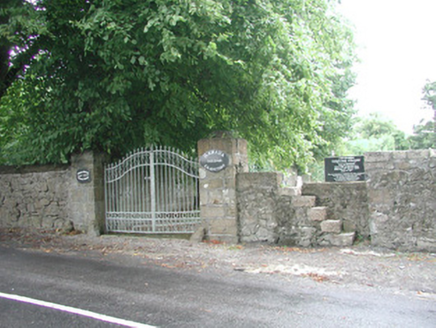 Banada GraveyardGraveyard/cemetery · 3.4 mi
Explorer Tom Banada Graveyard in Banada thinks the road leading to it is a bit of a show-off. It’s sitting on the site of a 1432 monastery that left no trace, which is like finding a receipt without the item. The roadside wall and gateway are pleasing, so just admire them from the public side without getting too nosy.
 Lough Talt TrailVisitor information · 3.9 mi
Explorer Tom Lough Talt Trail has a shortcut that is technically longer if you count the time spent arguing about which way is down. The water supply up there is public, but the ego of this trail seems to be private property. Get there early and have it all to yourself.
 Largan HillMountain / peak · 4.9 mi
Explorer Tom Largan Hill in County Sligo is strictly run by a terrier who barks at any cloud that passes overhead. The forest below looks young and confused, probably from all the shouting. Perfect detour when the satnav has a meltdown.
More archaeology and monuments in County Sligo · All of County Sligo

What do you know about this place?Tap to add a comment or ask a question