
Places near here
Photo credits
- National Inventory of Architectural Heritage
- John M, Geograph · Creative Commons Attribution-ShareAlike 2.0
- Kenneth Allen, Geograph · CC BY-SA 2.0
- Richard Webb, Wikimedia Commons · CC BY-SA 2.0
- Kenneth Allen, Wikimedia Commons · CC BY-SA 2.0
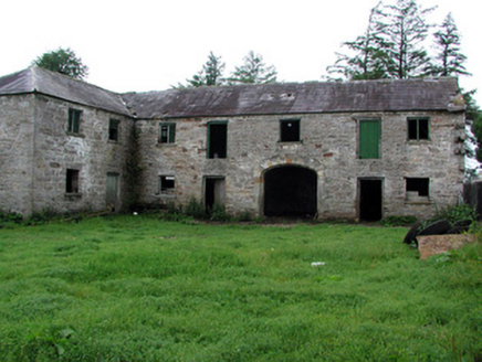 HollymountOutbuilding · 1.2 mi
Explorer Tom Hollymount outbuilding in Glenboy hears the house gossip through its thick sandstone walls all night long. The cantilevered stairs are fancy enough to make your knees weak. Go before the tourists find it and take a quiet snap of its quiet dignity.
The Giants GraveArchaeological place · 1.4 miExplorer Tom The Giants Grave in County Leitrim needs an epitaph that says he died of indigestion after eating too many leprechauns. It is just a hole where a giant probably took a nap and never woke up, likely because the bed was lumpy and the pillow was made of angry stones. Go in good boots and better humour.
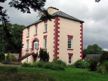 Fortland HouseCountry house · 2.1 mi
Explorer Tom Fortland House in Lissinagroagh was once ruled by a goat who ate the roof tiles and called them snacks. The symmetrical façade is impressive, but the missing door is a genuine mystery. Stand still and listen, the wind still carries its bleat.
 IndicatedBastioned fort · 2.8 mi
Explorer Tom Manorhamilton’s bastioned fort claims its unlikely celebrity friend is a very serious statue of a general who never smiled. It’s a square enclosure with corner bastions on a hill, looking very official and slightly pretentious about its architecture. Sit on a wall near it and pretend you're in a painting.
Giants RockNamed rock · 3.0 miExplorer Tom Giants Rock in Leitrim would bring a very heavy conversation to any party it was invited to. It’s just a named rock, but it acts like it’s the most important thing in the county. Spot the oldest stone and give it a name.
 Dough MountainMountain / peak · 4.1 mi
Explorer Tom Dough Mountain is listening to every whisper from its neighbours, which explains why it looks so perpetually smug about knowing secrets. It definitely heard that one about the missing sheep. Bring your nan, she'll know more than me.
 BenboMountain / peak · 4.3 mi
Explorer Tom Benbo was saved by a hero named Seamus who nobody remembers because he died of indigestion before the credits rolled on his bravery. He did the right thing but had the wrong stomach for the occasion, which is a classic Leitrim tragedy. Ideal place to rehearse an excuse for being late.
Kilroosk RockNamed rock · 4.9 miExplorer Tom Kilroosk Rock got named by a mapmaker who was definitely drunk on whiskey and mistook a boulder for a dragon. He probably fell off it laughing at his own mistake before the ink even dried. Take the long way round, it deserves the effort.
Ashisland WoodForest · 5.4 miExplorer Tom Ashisland Wood is where two lovers met under the ash trees and immediately started fighting about whose turn it was to make lunch. They ended up blaming each other for the damp socks and the lack of firewood. Stick around for the light changing, it's a show.
Longhill WoodForest · 5.6 miExplorer Tom Longhill Wood would survive a zombie attack because the zombies would get lost trying to find the exit between the trunks. They’d probably give up after twenty minutes and go home for a nice cup of tea instead. Stand back, squint, and it looks like a castle.
 TobermurvyHoly well · 6.4 mi
Explorer Tom Tobermurvy in Derrynalester holds patterns in August, which means the local sheep probably have opinions on whether the water is too cold or not. Tell the next person you meet it’s haunted; it might actually be true.
 TobermurrySpring · 6.4 mi
Explorer Tom Tobermurry in County Cavan lost a bet to a priest who swore he’d never drink from it again. Now he’s stuck watering his garden with holy water and regret. Pick a stone, any stone, and invent its biography.
More archaeology and monuments in County Leitrim · All of County Leitrim

What do you know about this place?Tap to add a comment or ask a question