
What is recorded here
From the National Monuments Service (Archaeological Survey of Ireland) record LE008-023002
Places near here
Photo credits
- National Inventory of Architectural Heritage
- Kenneth Allen, Geograph · CC BY-SA 2.0
- John M, Geograph · Creative Commons Attribution-ShareAlike 2.0
- Richard Webb, Geograph · CC BY-SA 2.0
- Kenneth Allen, Wikimedia Commons · CC BY-SA 2.0
- Gerard Lovett from ireland, Wikimedia Commons · CC BY 2.0
- Anne Burgess, Wikimedia Commons · CC BY-SA 2.0
- John Darcy, Wikimedia Commons · CC BY-SA 2.0
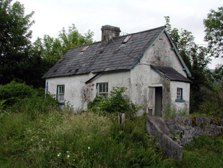 worker's house792 yd
Explorer Tom Lissinagroagh worker’s house nearly got famous for being right next to a level crossing. It kept its original features but lost most of its dignity. Go on, count the windows and feel sorry for the railway man.
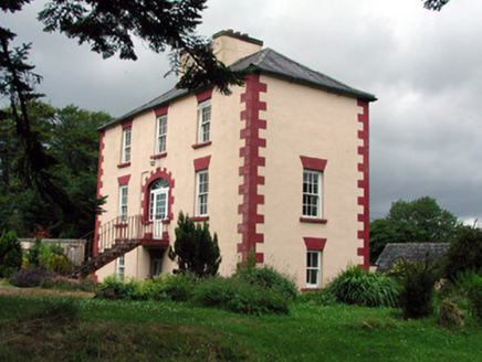 Fortland HouseCountry house · 903 yd
Explorer Tom Fortland House in Lissinagroagh was once ruled by a goat who ate the roof tiles and called them snacks. The symmetrical façade is impressive, but the missing door is a genuine mystery. Stand still and listen, the wind still carries its bleat.
 Dough MountainMountain / peak · 1.5 mi
 IndicatedBastioned fort · 2.5 mi
Explorer Tom Manorhamilton’s bastioned fort claims its unlikely celebrity friend is a very serious statue of a general who never smiled. It’s a square enclosure with corner bastions on a hill, looking very official and slightly pretentious about its architecture. Sit on a wall near it and pretend you're in a painting.
 Saddle HillMountain / peak · 2.7 mi
 Corracloona Court TombArchaeological place · 4.6 mi
 Lough MacNean WalkWalking route · 5.7 mi
 Rosscorkey IslandIsland · 7.2 mi
 TobermurrySpring · 7.9 mi
Explorer Tom As a holy well, Tobermurry might just wish you luck if you bow politely, so let's go see if the water is actually magical.
 Shannon PotSpring · 9.3 mi
Explorer Tom Shannon Pot is a spring in County Cavan, where the water reflections shine so brightly that even a polarizer filter cannot hide them.
 Cavan BurrenVisitor attraction · 9.5 mi
Explorer Tom Cavan Burren sounds like a rocky puzzle waiting to be solved, so grab your curiosity and head on over there.
 CastleCastle, tower house · 9.6 mi
Explorer Tom Castle in Kilmore would win the county fair for best dressed, even if it’s missing its hat. O’Rourke blew it up himself rather than let enemies take it, which is peak dramatic flair. Whisper a secret at it, it's kept worse.
More archaeology and monuments in County Leitrim · All of County Leitrim

What do you know about this place?Tap to add a comment or ask a question